
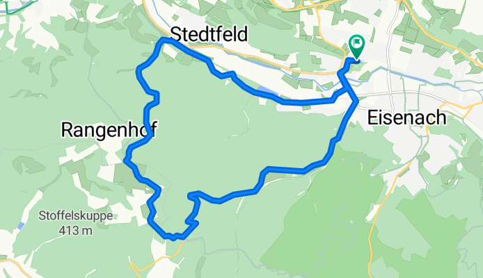
Siebenborn/Eisenach - Clausberg - Frankfurter Str./Eisenach
A cycling route starting in Eisenach, Free State of Thuringia, Germany.
Overview
About this route
Vom Siebenborn gelange ich über die Stedtfelder Teiche entlang dem Rangenbach, vorbei an einem alten Stollen, auf den Rennsteig bei Clausberg. Ich fahre dann rechtsabbiegend durch Clausberg und fahre die Rennsteig-Str. bis zur Landstraße nach Eisenach, wo ich dann auf die Frankfurter Str. komme. Von dort biege ich links auf die Kasseler Str. ab, und von dort wieder rechts zum Michelsbach und zur Michelskuppe, wo ich gestartet bin.
- -:--
- Duration
- 18 km
- Distance
- 284 m
- Ascent
- 283 m
- Descent
- ---
- Avg. speed
- ---
- Avg. speed
Route quality
Waytypes & surfaces along the route
Waytypes
Busy road
8.3 km
(46 %)
Track
2.9 km
(16 %)
Surfaces
Paved
12.9 km
(71 %)
Unpaved
2.9 km
(16 %)
Asphalt
12.9 km
(71 %)
Ground
2.5 km
(14 %)
Continue with Bikemap
Use, edit, or download this cycling route
You would like to ride Siebenborn/Eisenach - Clausberg - Frankfurter Str./Eisenach or customize it for your own trip? Here is what you can do with this Bikemap route:
Free features
- Save this route as favorite or in collections
- Copy & plan your own version of this route
- Sync your route with Garmin or Wahoo
Premium features
Free trial for 3 days, or one-time payment. More about Bikemap Premium.
- Navigate this route on iOS & Android
- Export a GPX / KML file of this route
- Create your custom printout (try it for free)
- Download this route for offline navigation
Discover more Premium features.
Get Bikemap PremiumFrom our community
Other popular routes starting in Eisenach
 Zentraler Thüringer Wald
- Distance
- 99.9 km
- Ascent
- 1,260 m
- Descent
- 1,260 m
- Location
- Eisenach, Free State of Thuringia, Germany
 Trailschaukel Eisenach
- Distance
- 35.8 km
- Ascent
- 923 m
- Descent
- 923 m
- Location
- Eisenach, Free State of Thuringia, Germany
 Rund um den Hainich_t
- Distance
- 116.4 km
- Ascent
- 1,237 m
- Descent
- 1,239 m
- Location
- Eisenach, Free State of Thuringia, Germany
 Katharinenstraße nach Tugendpfad
- Distance
- 2.7 km
- Ascent
- 192 m
- Descent
- 36 m
- Location
- Eisenach, Free State of Thuringia, Germany
 Westroute Thüringer Wald
- Distance
- 96 km
- Ascent
- 1,150 m
- Descent
- 1,150 m
- Location
- Eisenach, Free State of Thuringia, Germany
 kurze Tour
- Distance
- 17.3 km
- Ascent
- 213 m
- Descent
- 205 m
- Location
- Eisenach, Free State of Thuringia, Germany
 Thüringer Radfernwege - 11 - Thüringer Städtekette - D-Route 4
- Distance
- 233.6 km
- Ascent
- 1,500 m
- Descent
- 1,543 m
- Location
- Eisenach, Free State of Thuringia, Germany
 07.Wer.Eisen.-Philipst.
- Distance
- 195.8 km
- Ascent
- 2,079 m
- Descent
- 1,479 m
- Location
- Eisenach, Free State of Thuringia, Germany
Open it in the app