
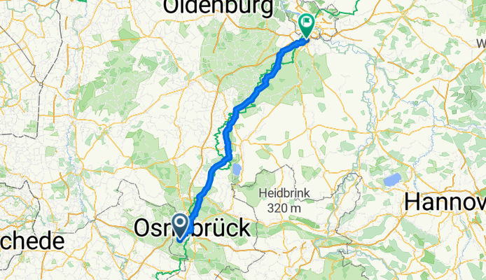
Hasbergen-Stuhr Tour 1985
A cycling route starting in Hasbergen, Lower Saxony, Germany.
Overview
About this route
Radstrecke von Osnabrück nach Stuhr über Nebenstrecken
- -:--
- Duration
- 126.8 km
- Distance
- 316 m
- Ascent
- 364 m
- Descent
- ---
- Avg. speed
- 156 m
- Avg. speed
Route quality
Waytypes & surfaces along the route
Waytypes
Quiet road
52.7 km
(42 %)
Path
27.3 km
(22 %)
Surfaces
Paved
112.1 km
(88 %)
Unpaved
3.1 km
(2 %)
Asphalt
99.2 km
(78 %)
Paving stones
10.2 km
(8 %)
Continue with Bikemap
Use, edit, or download this cycling route
You would like to ride Hasbergen-Stuhr Tour 1985 or customize it for your own trip? Here is what you can do with this Bikemap route:
Free features
- Save this route as favorite or in collections
- Copy & plan your own version of this route
- Sync your route with Garmin or Wahoo
Premium features
Free trial for 3 days, or one-time payment. More about Bikemap Premium.
- Navigate this route on iOS & Android
- Export a GPX / KML file of this route
- Create your custom printout (try it for free)
- Download this route for offline navigation
Discover more Premium features.
Get Bikemap PremiumFrom our community
Other popular routes starting in Hasbergen
 Teutotour klein
- Distance
- 55.9 km
- Ascent
- 490 m
- Descent
- 490 m
- Location
- Hasbergen, Lower Saxony, Germany
 Tecklenburg Extrem
- Distance
- 53.7 km
- Ascent
- 778 m
- Descent
- 761 m
- Location
- Hasbergen, Lower Saxony, Germany
 Rundfahrt Hasbergen West
- Distance
- 30.2 km
- Ascent
- 146 m
- Descent
- 145 m
- Location
- Hasbergen, Lower Saxony, Germany
 Hasbergen Eversburg Osnabrück Hasbergen
- Distance
- 25.1 km
- Ascent
- 55 m
- Descent
- 61 m
- Location
- Hasbergen, Lower Saxony, Germany
 Tecklenburger Straße 71, Hasbergen nach Tecklenburger Straße 71, Hasbergen
- Distance
- 15 km
- Ascent
- 76 m
- Descent
- 76 m
- Location
- Hasbergen, Lower Saxony, Germany
 TERRA.track: Erz-Steig - TERRA.track: Erz-Steig
- Distance
- 17.7 km
- Ascent
- 399 m
- Descent
- 399 m
- Location
- Hasbergen, Lower Saxony, Germany
 Meine erste Route
- Distance
- 14.9 km
- Ascent
- 83 m
- Descent
- 75 m
- Location
- Hasbergen, Lower Saxony, Germany
 Tecklenburg - Münster - Tecklenburg
- Distance
- 108 km
- Ascent
- 220 m
- Descent
- 220 m
- Location
- Hasbergen, Lower Saxony, Germany
Open it in the app