
ñlkñkljñjkñ
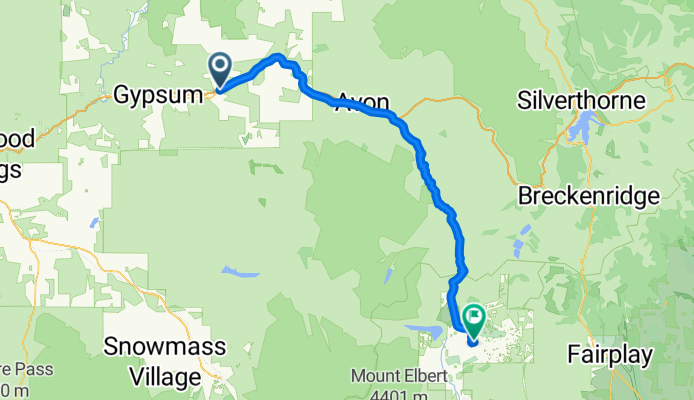
A cycling route starting in Eagle, Colorado, United States of America.
Overview
About this route
ñljkñljkñjkñ
- -:--
- Duration
- 92 km
- Distance
- 1,412 m
- Ascent
- 318 m
- Descent
- ---
- Avg. speed
- ---
- Avg. speed
Route quality
Waytypes & surfaces along the route
Waytypes
Busy road
82 km
(89 %)
Quiet road
5 km
(5 %)
Surfaces
Paved
89.2 km
(97 %)
Paved (undefined)
51.4 km
(56 %)
Asphalt
37.8 km
(41 %)
Undefined
2.7 km
(3 %)
Continue with Bikemap
Use, edit, or download this cycling route
You would like to ride ñlkñkljñjkñ or customize it for your own trip? Here is what you can do with this Bikemap route:
Free features
- Save this route as favorite or in collections
- Copy & plan your own version of this route
- Sync your route with Garmin or Wahoo
Premium features
Free trial for 3 days, or one-time payment. More about Bikemap Premium.
- Navigate this route on iOS & Android
- Export a GPX / KML file of this route
- Create your custom printout (try it for free)
- Download this route for offline navigation
Discover more Premium features.
Get Bikemap PremiumFrom our community
Other popular routes starting in Eagle
 ñlkñkljñjkñ
- Distance
- 92 km
- Ascent
- 1,412 m
- Descent
- 318 m
- Location
- Eagle, Colorado, United States of America
 2017-06-27. Eagle - Glenwood Springs
- Distance
- 53 km
- Ascent
- 408 m
- Descent
- 690 m
- Location
- Eagle, Colorado, United States of America
 Route in Eagle
- Distance
- 1.8 km
- Ascent
- 16 m
- Descent
- 34 m
- Location
- Eagle, Colorado, United States of America
 Sylvan Lake
- Distance
- 20.4 km
- Ascent
- 344 m
- Descent
- 336 m
- Location
- Eagle, Colorado, United States of America
 8.24.2019 92 days until Ironman
- Distance
- 51.9 km
- Ascent
- 119 m
- Descent
- 376 m
- Location
- Eagle, Colorado, United States of America
 EAGLE-PARACHUTE
- Distance
- 121.3 km
- Ascent
- 388 m
- Descent
- 840 m
- Location
- Eagle, Colorado, United States of America
Open it in the app