

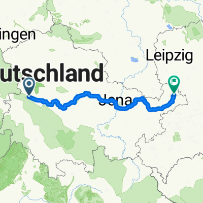
Karolinenbrücke-Hötzelsroda-Plastic Omnium-Hötzelsroda-Neukirchen-Madelungen-Stregda (Media Markt)-Eisenach am 13.1.2015
A cycling route starting in Eisenach, Free State of Thuringia, Germany.
Overview
About this route
Ich starte an der Michelskuppe und fahre die Hörsel entlang bis zur Karolinenstr., wo ich die ehemalige Autobahnbrücke unterquere und dann an den Häusern u. Gärten vorbei nach Hötzelsroda bis zum Kreisverkehr fahre, wo ich der Essener Straße bis Plastic-Omnium folge. Dort biege ich auf die landwirtschaftliche Straße ab, der ich bis kurz vor der Autobahn-Unterquerung folge, dann aber links abbiege und so an den Feldern vorbei nach Hötzelsroda gelange. Dort folge ich der landwirtschaftl. Straße nach Neukirchen und von dort der landw. Straße nach Madelungen, wo ich nach Stregda/Eisenach abbiege und auch die A4 überfahre (Brücke).
- -:--
- Duration
- 23.4 km
- Distance
- 275 m
- Ascent
- 273 m
- Descent
- ---
- Avg. speed
- ---
- Avg. speed
Route quality
Waytypes & surfaces along the route
Waytypes
Quiet road
7.7 km
(33 %)
Road
5 km
(22 %)
Surfaces
Paved
9.7 km
(42 %)
Unpaved
2 km
(8 %)
Asphalt
7.6 km
(33 %)
Gravel
1.3 km
(5 %)
Continue with Bikemap
Use, edit, or download this cycling route
You would like to ride Karolinenbrücke-Hötzelsroda-Plastic Omnium-Hötzelsroda-Neukirchen-Madelungen-Stregda (Media Markt)-Eisenach am 13.1.2015 or customize it for your own trip? Here is what you can do with this Bikemap route:
Free features
- Save this route as favorite or in collections
- Copy & plan your own version of this route
- Sync your route with Garmin or Wahoo
Premium features
Free trial for 3 days, or one-time payment. More about Bikemap Premium.
- Navigate this route on iOS & Android
- Export a GPX / KML file of this route
- Create your custom printout (try it for free)
- Download this route for offline navigation
Discover more Premium features.
Get Bikemap PremiumFrom our community
Other popular routes starting in Eisenach
 Thüringer Radfernwege - 11 - Thüringer Städtekette - D-Route 4
- Distance
- 233.6 km
- Ascent
- 1,500 m
- Descent
- 1,543 m
- Location
- Eisenach, Free State of Thuringia, Germany
 Rund um den Hainich_t
- Distance
- 116.4 km
- Ascent
- 1,237 m
- Descent
- 1,239 m
- Location
- Eisenach, Free State of Thuringia, Germany
 Katharinenstraße nach Tugendpfad
- Distance
- 2.7 km
- Ascent
- 192 m
- Descent
- 36 m
- Location
- Eisenach, Free State of Thuringia, Germany
 Goethestraße, Eisenach nach Planstraße, Amt Creuzburg
- Distance
- 26.1 km
- Ascent
- 394 m
- Descent
- 431 m
- Location
- Eisenach, Free State of Thuringia, Germany
 Westroute Thüringer Wald
- Distance
- 96 km
- Ascent
- 1,150 m
- Descent
- 1,150 m
- Location
- Eisenach, Free State of Thuringia, Germany
 Karlstraße nach Gartenstraße
- Distance
- 27.6 km
- Ascent
- 227 m
- Descent
- 239 m
- Location
- Eisenach, Free State of Thuringia, Germany
 Zentraler Thüringer Wald
- Distance
- 99.9 km
- Ascent
- 1,260 m
- Descent
- 1,260 m
- Location
- Eisenach, Free State of Thuringia, Germany
 Eisenach-Gotha
- Distance
- 43.2 km
- Ascent
- 272 m
- Descent
- 190 m
- Location
- Eisenach, Free State of Thuringia, Germany
Open it in the app