

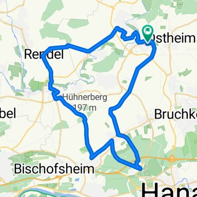
Nidderau nach Hanau
A cycling route starting in Nidderau, Hesse, Germany.
Overview
About this route
Die Route führt an der B45 entlang auf einem separaten Radweg bis Bruchköbel und führt weiter an der Bahnstrecke bis nach Hauau
- -:--
- Duration
- 14.3 km
- Distance
- 55 m
- Ascent
- 82 m
- Descent
- ---
- Avg. speed
- ---
- Avg. speed

Route quality
Waytypes & surfaces along the route
Waytypes
Quiet road
5.8 km
(41 %)
Path
2.6 km
(18 %)
Surfaces
Paved
12.7 km
(89 %)
Unpaved
0.6 km
(5 %)
Asphalt
11.6 km
(81 %)
Loose gravel
0.6 km
(4 %)
Continue with Bikemap
Use, edit, or download this cycling route
You would like to ride Nidderau nach Hanau or customize it for your own trip? Here is what you can do with this Bikemap route:
Free features
- Save this route as favorite or in collections
- Copy & plan your own version of this route
- Sync your route with Garmin or Wahoo
Premium features
Free trial for 3 days, or one-time payment. More about Bikemap Premium.
- Navigate this route on iOS & Android
- Export a GPX / KML file of this route
- Create your custom printout (try it for free)
- Download this route for offline navigation
Discover more Premium features.
Get Bikemap PremiumFrom our community
Other popular routes starting in Nidderau
 Hoherodskopf - die schöne Variante
- Distance
- 137.9 km
- Ascent
- 1,391 m
- Descent
- 1,372 m
- Location
- Nidderau, Hesse, Germany
 Südstraße 1, Niddatal nach Freigerichtstraße 42B, Niddatal
- Distance
- 27.4 km
- Ascent
- 430 m
- Descent
- 428 m
- Location
- Nidderau, Hesse, Germany
 Nidderau Runde
- Distance
- 16.9 km
- Ascent
- 108 m
- Descent
- 116 m
- Location
- Nidderau, Hesse, Germany
 Nidderauer Auslauf
- Distance
- 87.8 km
- Ascent
- 446 m
- Descent
- 446 m
- Location
- Nidderau, Hesse, Germany
 BRT_2018-RC03_Ilbenstadt-G-V04
- Distance
- 227.7 km
- Ascent
- 895 m
- Descent
- 907 m
- Location
- Nidderau, Hesse, Germany
 Windecken - Hohe Strasse - Maintal
- Distance
- 33.8 km
- Ascent
- 228 m
- Descent
- 247 m
- Location
- Nidderau, Hesse, Germany
 Nidderau 50 km (Büdingen, Ronneburg)
- Distance
- 48.5 km
- Ascent
- 257 m
- Descent
- 256 m
- Location
- Nidderau, Hesse, Germany
 Bergroute - Emil-Nolde-Straße 22D, Nidderau nach Emil-Nolde-Straße 22D, Nidderau
- Distance
- 11.9 km
- Ascent
- 116 m
- Descent
- 118 m
- Location
- Nidderau, Hesse, Germany
Open it in the app