<div class="oax_marg_bottom_44" style="margin: 0px 0px 44px; padding: 0px; border: 0px; font-family: ASAP, sans-serif; font-stretch: inherit; line-height: 24px; font-size: 16px; vertical-align: baseline; box-sizing: content-box; word-wrap: break-word; color: rgb(51, 51, 51);">
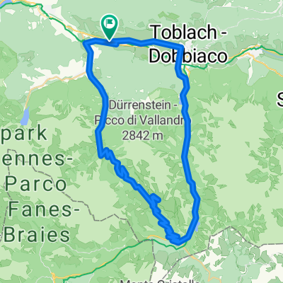
von Niederdorf über Altprags zur Plätzwiese und zurück. Alternativ weiter über die Dürrensteinhütte runter zum Dürrensee und über Toblach zurück.</div>
<h2 class="oax_h2 oax_headline_color" style="margin: 0px; padding: 0px; border: 0px; font-family: ASAP; font-stretch: inherit; line-height: 19px; font-size: 16px; vertical-align: baseline; box-sizing: content-box; word-wrap: break-word; text-transform: uppercase; color: rgb(82, 90, 15);">
DOLOMITEN KRONPLATZ: RADTOUR</h2>
<div class="oax_marg_bottom_44" style="margin: 0px 0px 44px; padding: 0px; border: 0px; font-family: ASAP, sans-serif; font-stretch: inherit; line-height: 24px; font-size: 16px; vertical-align: baseline; box-sizing: content-box; word-wrap: break-word; color: rgb(51, 51, 51);">
von Niederdorf über den Radweg Richtung Brixen. Nach dem Militärgelände links halten Richtung Pragser Tal. Bei der Weggabelung (Touristinformation) links halten Richtung Altprags bzw. Plätzwiese. Bis Brückele (ab da für KFZ Mautstraße) geht es stetig aber moderat bergauf. Ab Brückele sind für die letzten 5 Km 500 Höhenmeter zu fahren. Daher ist die Strecke für Mountainbikes oder E Bikes geeignet, weniger für Tourenräder. Alternativ besteht die Möglichkeit weiter zu fahren über die Dürrensteinhütte auf einer alten Militärstraße hinunter zum Dürrensee und vorbei am Toblacher See und Toblach zurück nach Niederdorf.</div>
<div>
</div>


