

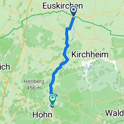
EU-Abendroute (nördlich EU)
A cycling route starting in Euskirchen, North Rhine-Westphalia, Germany.
Overview
About this route
suitable for sporty riding, if you skip the last twist at the Erft (gravel paths)
- -:--
- Duration
- 29 km
- Distance
- 40 m
- Ascent
- 46 m
- Descent
- ---
- Avg. speed
- 162 m
- Max. altitude

Route quality
Waytypes & surfaces along the route
Waytypes
Track
23.8 km
(82 %)
Quiet road
2.3 km
(8 %)
Surfaces
Paved
26.7 km
(92 %)
Unpaved
1.2 km
(4 %)
Asphalt
13.6 km
(47 %)
Paved (undefined)
13.1 km
(45 %)
Continue with Bikemap
Use, edit, or download this cycling route
You would like to ride EU-Abendroute (nördlich EU) or customize it for your own trip? Here is what you can do with this Bikemap route:
Free features
- Save this route as favorite or in collections
- Copy & plan your own version of this route
- Sync your route with Garmin or Wahoo
Premium features
Free trial for 3 days, or one-time payment. More about Bikemap Premium.
- Navigate this route on iOS & Android
- Export a GPX / KML file of this route
- Create your custom printout (try it for free)
- Download this route for offline navigation
Discover more Premium features.
Get Bikemap PremiumFrom our community
Other popular routes starting in Euskirchen
 Jahnstraße 1I nach Jahnstraße
- Distance
- 23.9 km
- Ascent
- 175 m
- Descent
- 223 m
- Location
- Euskirchen, North Rhine-Westphalia, Germany
 EU - Bleibtreusee - EU
- Distance
- 58.1 km
- Ascent
- 131 m
- Descent
- 151 m
- Location
- Euskirchen, North Rhine-Westphalia, Germany
 EU-Bleibtreusee-EU
- Distance
- 58.2 km
- Ascent
- 186 m
- Descent
- 182 m
- Location
- Euskirchen, North Rhine-Westphalia, Germany
 Rodderbach 55, Euskirchen nach Rodderbach 55, Euskirchen
- Distance
- 19.1 km
- Ascent
- 160 m
- Descent
- 157 m
- Location
- Euskirchen, North Rhine-Westphalia, Germany
 Von Euskirchen bis Sankt Augustin
- Distance
- 40.3 km
- Ascent
- 95 m
- Descent
- 204 m
- Location
- Euskirchen, North Rhine-Westphalia, Germany
 7_Stotzenheim - Bad Münstereifel
- Distance
- 15.3 km
- Ascent
- 332 m
- Descent
- 127 m
- Location
- Euskirchen, North Rhine-Westphalia, Germany
 Euskirchen Eifelrunde1
- Distance
- 69.2 km
- Ascent
- 814 m
- Descent
- 726 m
- Location
- Euskirchen, North Rhine-Westphalia, Germany
 Euskirchen- Aachen Altstr.54
- Distance
- 79.4 km
- Ascent
- 324 m
- Descent
- 304 m
- Location
- Euskirchen, North Rhine-Westphalia, Germany
Open it in the app