

Markt Eygelshoven <> Centrum Alsdorf
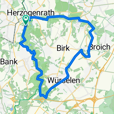
A cycling route starting in Herzogenrath, North Rhine-Westphalia, Germany.
Overview
About this route
Leuke route door natuurpark 90% verhard.
Koffie in Eygelshoven en uiteraard ook in Alsdorf- -:--
- Duration
- 21.3 km
- Distance
- 156 m
- Ascent
- 153 m
- Descent
- ---
- Avg. speed
- ---
- Avg. speed

Route quality
Waytypes & surfaces along the route
Waytypes
Quiet road
6.2 km
(29 %)
Road
5 km
(23 %)
Surfaces
Paved
12.3 km
(58 %)
Unpaved
3.1 km
(15 %)
Asphalt
10.5 km
(49 %)
Gravel
1.4 km
(7 %)
Continue with Bikemap
Use, edit, or download this cycling route
You would like to ride Markt Eygelshoven <> Centrum Alsdorf or customize it for your own trip? Here is what you can do with this Bikemap route:
Free features
- Save this route as favorite or in collections
- Copy & plan your own version of this route
- Sync your route with Garmin or Wahoo
Premium features
Free trial for 3 days, or one-time payment. More about Bikemap Premium.
- Navigate this route on iOS & Android
- Export a GPX / KML file of this route
- Create your custom printout (try it for free)
- Download this route for offline navigation
Discover more Premium features.
Get Bikemap PremiumFrom our community
Other popular routes starting in Herzogenrath
 An Wurm und Broichbach
- Distance
- 28.4 km
- Ascent
- 133 m
- Descent
- 111 m
- Location
- Herzogenrath, North Rhine-Westphalia, Germany
 Airbase Rund
- Distance
- 39.4 km
- Ascent
- 140 m
- Descent
- 154 m
- Location
- Herzogenrath, North Rhine-Westphalia, Germany
 Tolle Landschaftsroute CLONED FROM ROUTE 220895
- Distance
- 25.5 km
- Ascent
- 162 m
- Descent
- 162 m
- Location
- Herzogenrath, North Rhine-Westphalia, Germany
 AZAN Tour 4 Durch Den Norden Der Städteregion
- Distance
- 29.4 km
- Ascent
- 162 m
- Descent
- 163 m
- Location
- Herzogenrath, North Rhine-Westphalia, Germany
 Rund um Merkstein mit Aufstieg
- Distance
- 14.7 km
- Ascent
- 180 m
- Descent
- 182 m
- Location
- Herzogenrath, North Rhine-Westphalia, Germany
 Rund um den See
- Distance
- 40 km
- Ascent
- 127 m
- Descent
- 103 m
- Location
- Herzogenrath, North Rhine-Westphalia, Germany
 WINFOR
- Distance
- 23.3 km
- Ascent
- 110 m
- Descent
- 120 m
- Location
- Herzogenrath, North Rhine-Westphalia, Germany
 Tolle Landschaftsroute
- Distance
- 25.5 km
- Ascent
- 205 m
- Descent
- 222 m
- Location
- Herzogenrath, North Rhine-Westphalia, Germany
Open it in the app