
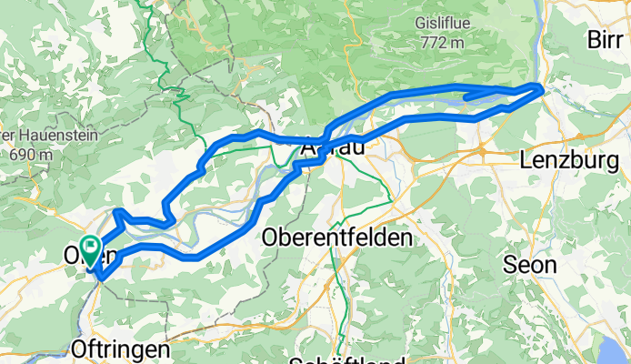
Olten - Wildegg - Rohr - Olten
A cycling route starting in Olten, Canton of Solothurn, Switzerland.
Overview
About this route
Olten - Wildegg - Rohr - Olten
- -:--
- Duration
- 55.3 km
- Distance
- 307 m
- Ascent
- 307 m
- Descent
- ---
- Avg. speed
- ---
- Avg. speed
Route quality
Waytypes & surfaces along the route
Waytypes
Busy road
21 km
(38 %)
Quiet road
14.1 km
(25 %)
Surfaces
Paved
29.5 km
(53 %)
Asphalt
27.8 km
(50 %)
Paved (undefined)
1.6 km
(3 %)
Continue with Bikemap
Use, edit, or download this cycling route
You would like to ride Olten - Wildegg - Rohr - Olten or customize it for your own trip? Here is what you can do with this Bikemap route:
Free features
- Save this route as favorite or in collections
- Copy & plan your own version of this route
- Sync your route with Garmin or Wahoo
Premium features
Free trial for 3 days, or one-time payment. More about Bikemap Premium.
- Navigate this route on iOS & Android
- Export a GPX / KML file of this route
- Create your custom printout (try it for free)
- Download this route for offline navigation
Discover more Premium features.
Get Bikemap PremiumFrom our community
Other popular routes starting in Olten
 Schafmattrunde Olten
- Distance
- 37.3 km
- Ascent
- 909 m
- Descent
- 890 m
- Location
- Olten, Canton of Solothurn, Switzerland
 Glaubenberg, Glaubenbüehlen, Lüderealp
- Distance
- 208.4 km
- Ascent
- 2,690 m
- Descent
- 2,703 m
- Location
- Olten, Canton of Solothurn, Switzerland
 Olten - Hauenstein - Schaafmatt - Olten
- Distance
- 31.5 km
- Ascent
- 652 m
- Descent
- 655 m
- Location
- Olten, Canton of Solothurn, Switzerland
 Scheltenpass mit Weissenstein
- Distance
- 79.6 km
- Ascent
- 1,597 m
- Descent
- 1,558 m
- Location
- Olten, Canton of Solothurn, Switzerland
 3-TagesTour 2 - Olten - Waldshut
- Distance
- 93.7 km
- Ascent
- 978 m
- Descent
- 1,036 m
- Location
- Olten, Canton of Solothurn, Switzerland
 Schützenmattweg 12, Olten nach Forstackerstrasse 4F, Zofingen
- Distance
- 10 km
- Ascent
- 84 m
- Descent
- 38 m
- Location
- Olten, Canton of Solothurn, Switzerland
 Grenchenberg Corcelles Schelten
- Distance
- 149 km
- Ascent
- 2,318 m
- Descent
- 2,318 m
- Location
- Olten, Canton of Solothurn, Switzerland
 Tüüfelsschlucht - Brunnersberg - Schmiedenmatt
- Distance
- 77.7 km
- Ascent
- 1,616 m
- Descent
- 1,619 m
- Location
- Olten, Canton of Solothurn, Switzerland
Open it in the app