Türbotour_44
- 53.4 km
- 207 m
- 461 m
- Kiens, Trentino-Alto Adige, Italy
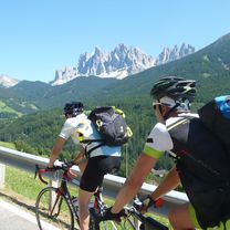
A cycling route starting in Kiens, Trentino-Alto Adige, Italy.
Overview
Note:
Parking – Astjoch 1 hour 45 minutes, Astjoch – Starkenfeld Hut 45 minutes, Starkenfeld Hut – Parking 1 hour 15 minutes. Total 3 hours 45 minutes.
Kronplatz. With such praise from authoritative sources, it is hardly surprising that the Alpine Club already built a house on the Kronplatz in 1895, as a stop and accommodation for those who, equipped with alpine staff and sunhat, climbed from Bruneck up to the great viewpoint. Those who do it today experience a very different mountain (although the view is still the same), heavily marked by mass skiing. And whether the newest attraction, the 18-ton peace bell with its walkable panoramic platform, means that man has made peace with nature, I dare to doubt. The next big project (cable car and piste from Percha) is already under discussion. At least considerable resistance is rising among the population. The little neighbor. We want it quiet, can do without flat groomed slopes, and much prefer grazing cows to iron lift masts. Nature, shaped by man but not disfigured. As for example at Astjoch (2194 m). It marks the highest point of an extensive alpine pasture and hiking area that extends west of the Kronplatz between the Lüsen Valley and the confluence gorge of the Gader, over ten square kilometers large and gently rolling. There are also several high moors, some small tarns – and a few inviting huts on the quartz phyllite ridge. One enjoys a great panorama from Astjoch (Burgstall), almost equal to Kronplatz, which – as can be read on the original summit marker made of stones – extends from Adamello in the southwest to Austria’s highest, the Großglockner. To the great view. The tour starts at the parking lot (1550 m) above Ellen. Follow the asphalt road briefly and then turn left onto the red and white marked trail no. 67. Now an agreeable ascent, mostly shaded uphill, crossing twice a wide forest road. After about an hour the Walderalm (1908 m) is reached on a beautiful slope with magnificent views of the wide Bruneck basin. A quarter of an hour higher, the path leads into a sandy road that gently rises to the Kaserhütten (2110 m). At least a sideways glance is deserved by the original "trophies" on the house wall as well as the "edelweiss wall" before heading over open meadows to the cross visible from afar at Astjoch (2194 m; 1 hour 45 minutes). The panorama is immense and pretty exactly to the east and just over ten kilometers – but half a world away – the Kronplatz. Refreshment stop. From the flattened ridge, follow the markings down small rock steps to the Astalm hollow (1954 m). It stays to the right, as does the protected high moor. Walk flat on a gravel road over to the Starkenfeld Hut (1936 m; 2 hours 30 minutes) in a nice scenic location. The eye-catcher to the south is the Peitlerkofel (2875 m) with its mighty north face. Only just a quarter hour further (signpost) the Rastner Hut (1931 m) already awaits the next refreshment opportunity. Apple strudel or Kaiserschmarrn? Descent. Go back a short distance on the sandy road and then leave it to the left (signpost "Ellen"). The path runs along a wooden fence, leads to a narrow passage and shortly after to a small moor lake (1930 m). Pass it on the left, then continue downhill on the forested slope following signs no. 67, later no. 67b. Finally, you reach a forest road that, via two loops (shortcut possible), leads back to the starting point of this beautiful circuit above Ellen (3 hours 45 minutes).
created this 10 years ago
Continue with Bikemap
You would like to ride Zum Astjoch or customize it for your own trip? Here is what you can do with this Bikemap route:
Free trial for 3 days, or one-time payment. More about Bikemap Premium.
Discover more Premium features.
Get Bikemap PremiumFrom our community
Open it in the app