

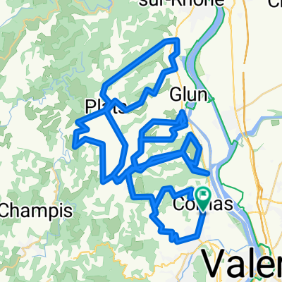
St Romain sud ouest
A cycling route starting in Cornas, Auvergne-Rhône-Alpes, France.
Overview
About this route
Ardéche vallée du rhone Alboussière
- -:--
- Duration
- 52.8 km
- Distance
- 893 m
- Ascent
- 894 m
- Descent
- ---
- Avg. speed
- ---
- Avg. speed

Route quality
Waytypes & surfaces along the route
Waytypes
Road
21.8 km
(41 %)
Busy road
16.7 km
(32 %)
Surfaces
Paved
9.3 km
(18 %)
Unpaved
0.4 km
(<1 %)
Asphalt
9.2 km
(17 %)
Ground
0.4 km
(<1 %)
Continue with Bikemap
Use, edit, or download this cycling route
You would like to ride St Romain sud ouest or customize it for your own trip? Here is what you can do with this Bikemap route:
Free features
- Save this route as favorite or in collections
- Copy & plan your own version of this route
- Sync your route with Garmin or Wahoo
Premium features
Free trial for 3 days, or one-time payment. More about Bikemap Premium.
- Navigate this route on iOS & Android
- Export a GPX / KML file of this route
- Create your custom printout (try it for free)
- Download this route for offline navigation
Discover more Premium features.
Get Bikemap PremiumFrom our community
Other popular routes starting in Cornas
 St Romain sud ouest
- Distance
- 52.8 km
- Ascent
- 893 m
- Descent
- 894 m
- Location
- Cornas, Auvergne-Rhône-Alpes, France
 Saint Romain - Vernoux
- Distance
- 47.2 km
- Ascent
- 654 m
- Descent
- 660 m
- Location
- Cornas, Auvergne-Rhône-Alpes, France
 St romain ouest
- Distance
- 55.8 km
- Ascent
- 827 m
- Descent
- 828 m
- Location
- Cornas, Auvergne-Rhône-Alpes, France
 20 avril Traverseée de Valence
- Distance
- 45.4 km
- Ascent
- 100 m
- Descent
- 102 m
- Location
- Cornas, Auvergne-Rhône-Alpes, France
 Côteaux de St-Péray
- Distance
- 95.5 km
- Ascent
- 2,386 m
- Descent
- 2,386 m
- Location
- Cornas, Auvergne-Rhône-Alpes, France
 St romain ouest
- Distance
- 55.8 km
- Ascent
- 827 m
- Descent
- 828 m
- Location
- Cornas, Auvergne-Rhône-Alpes, France
 Ardechoise dossard
- Distance
- 29.1 km
- Ascent
- 662 m
- Descent
- 533 m
- Location
- Cornas, Auvergne-Rhône-Alpes, France
 Balade Chantelermuze 2016 -25 septembre 13:38
- Distance
- 12.2 km
- Ascent
- 329 m
- Descent
- 329 m
- Location
- Cornas, Auvergne-Rhône-Alpes, France
Open it in the app