
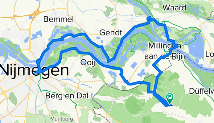
von Mehr - Millingen - Fähre nach Tolkamer - dann bis Nijmegen über die Brücke und zurück am Waal bis Mehr ca. 50 km-
A cycling route starting in Kranenburg, North Rhine-Westphalia, Germany.
Overview
About this route
Radtour entlang des Rheins und des Waals von Millingen a. d. Rh. (Grenze) bis Nijmegen auf beiden Seiten des Stroms bei Nutzung zweier Fähren und der Brücke in Nijmegen.
- -:--
- Duration
- 47.7 km
- Distance
- 37 m
- Ascent
- 38 m
- Descent
- ---
- Avg. speed
- ---
- Avg. speed
Route quality
Waytypes & surfaces along the route
Waytypes
Quiet road
28.7 km
(60 %)
Road
12.9 km
(27 %)
Surfaces
Paved
21.6 km
(45 %)
Unpaved
0.6 km
(1 %)
Asphalt
19 km
(40 %)
Paving stones
2 km
(4 %)
Continue with Bikemap
Use, edit, or download this cycling route
You would like to ride von Mehr - Millingen - Fähre nach Tolkamer - dann bis Nijmegen über die Brücke und zurück am Waal bis Mehr ca. 50 km- or customize it for your own trip? Here is what you can do with this Bikemap route:
Free features
- Save this route as favorite or in collections
- Copy & plan your own version of this route
- Sync your route with Garmin or Wahoo
Premium features
Free trial for 3 days, or one-time payment. More about Bikemap Premium.
- Navigate this route on iOS & Android
- Export a GPX / KML file of this route
- Create your custom printout (try it for free)
- Download this route for offline navigation
Discover more Premium features.
Get Bikemap PremiumFrom our community
Other popular routes starting in Kranenburg
 Groesbeek NK Marathon 2010
- Distance
- 85.1 km
- Ascent
- 369 m
- Descent
- 369 m
- Location
- Kranenburg, North Rhine-Westphalia, Germany
 Rondje Reichswald
- Distance
- 46.4 km
- Ascent
- 401 m
- Descent
- 401 m
- Location
- Kranenburg, North Rhine-Westphalia, Germany
 Gisbertstraße 13C nach De Kamp
- Distance
- 32.6 km
- Ascent
- 92 m
- Descent
- 92 m
- Location
- Kranenburg, North Rhine-Westphalia, Germany
 Thomas kleine Runde mit Gastro
- Distance
- 24.4 km
- Ascent
- 16 m
- Descent
- 16 m
- Location
- Kranenburg, North Rhine-Westphalia, Germany
 Grunewald Runde
- Distance
- 70.5 km
- Ascent
- 248 m
- Descent
- 230 m
- Location
- Kranenburg, North Rhine-Westphalia, Germany
 Trailrondje Reichswald
- Distance
- 16.4 km
- Ascent
- 146 m
- Descent
- 149 m
- Location
- Kranenburg, North Rhine-Westphalia, Germany
 DD 9.
DD 9.- Distance
- 53.5 km
- Ascent
- 111 m
- Descent
- 107 m
- Location
- Kranenburg, North Rhine-Westphalia, Germany
 Maasroute
- Distance
- 70.4 km
- Ascent
- 81 m
- Descent
- 82 m
- Location
- Kranenburg, North Rhine-Westphalia, Germany
Open it in the app