
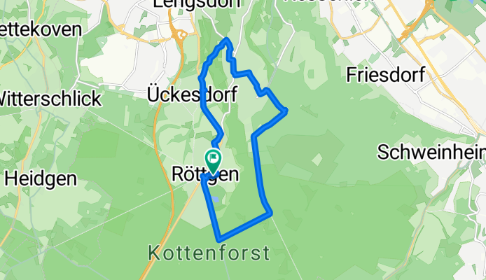
xRöttgen Waldau Ückesdorf
A cycling route starting in Wachtberg, North Rhine-Westphalia, Germany.
Overview
About this route
12.04.15 15:08 (cloned from route 2973167)
- -:--
- Duration
- 11.6 km
- Distance
- 97 m
- Ascent
- 97 m
- Descent
- ---
- Avg. speed
- ---
- Avg. speed
Continue with Bikemap
Use, edit, or download this cycling route
You would like to ride xRöttgen Waldau Ückesdorf or customize it for your own trip? Here is what you can do with this Bikemap route:
Free features
- Save this route as favorite or in collections
- Copy & plan your own version of this route
- Sync your route with Garmin or Wahoo
Premium features
Free trial for 3 days, or one-time payment. More about Bikemap Premium.
- Navigate this route on iOS & Android
- Export a GPX / KML file of this route
- Create your custom printout (try it for free)
- Download this route for offline navigation
Discover more Premium features.
Get Bikemap PremiumFrom our community
Other popular routes starting in Wachtberg
 To work über Promenadenweg
- Distance
- 18.5 km
- Ascent
- 108 m
- Descent
- 267 m
- Location
- Wachtberg, North Rhine-Westphalia, Germany
 Höchelenacker 3, Wachtberg nach Höchelenacker 3, Wachtberg
- Distance
- 19.5 km
- Ascent
- 47 m
- Descent
- 134 m
- Location
- Wachtberg, North Rhine-Westphalia, Germany
 hausrunde werthhoven
- Distance
- 31.8 km
- Ascent
- 303 m
- Descent
- 367 m
- Location
- Wachtberg, North Rhine-Westphalia, Germany
 An den Obstgärten 17, Wachtberg nach An den Obstgärten 18, Wachtberg
- Distance
- 55.5 km
- Ascent
- 689 m
- Descent
- 682 m
- Location
- Wachtberg, North Rhine-Westphalia, Germany
 Apfelroute 6 Wachtberg-Schleife
- Distance
- 18.9 km
- Ascent
- 192 m
- Descent
- 190 m
- Location
- Wachtberg, North Rhine-Westphalia, Germany
 Recovered Route
- Distance
- 96.3 km
- Ascent
- 416 m
- Descent
- 540 m
- Location
- Wachtberg, North Rhine-Westphalia, Germany
 Zwei Hüttentour: Zur Akropolis und dann zum Steinerberghaus rauf
- Distance
- 42.8 km
- Ascent
- 865 m
- Descent
- 847 m
- Location
- Wachtberg, North Rhine-Westphalia, Germany
 Golfplatz Züllighoven und ins Tal nach Calmuth
- Distance
- 30.5 km
- Ascent
- 335 m
- Descent
- 335 m
- Location
- Wachtberg, North Rhine-Westphalia, Germany
Open it in the app