
Hig-Fuerstenhagen-Lutter-Hig.gpx
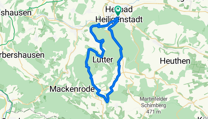
A cycling route starting in Heilbad Heiligenstadt, Free State of Thuringia, Germany.
Overview
About this route
Diese Tour führt durch den Heiligenstädter Stadtwald über die Dieteröderklippen nach Fürstenhagen. Von hieraus weiter nach Lutter am Schierbachteich vorbei zurück nach Heiligenstadt.
- -:--
- Duration
- 27.8 km
- Distance
- 468 m
- Ascent
- 468 m
- Descent
- ---
- Avg. speed
- ---
- Avg. speed
Continue with Bikemap
Use, edit, or download this cycling route
You would like to ride Hig-Fuerstenhagen-Lutter-Hig.gpx or customize it for your own trip? Here is what you can do with this Bikemap route:
Free features
- Save this route as favorite or in collections
- Copy & plan your own version of this route
- Sync your route with Garmin or Wahoo
Premium features
Free trial for 3 days, or one-time payment. More about Bikemap Premium.
- Navigate this route on iOS & Android
- Export a GPX / KML file of this route
- Create your custom printout (try it for free)
- Download this route for offline navigation
Discover more Premium features.
Get Bikemap PremiumFrom our community
Other popular routes starting in Heilbad Heiligenstadt
 Arensh.- Oberst.- Eckstieg- Marth- Opferstein- Burgwalde- u.z.
- Distance
- 33.5 km
- Ascent
- 243 m
- Descent
- 243 m
- Location
- Heilbad Heiligenstadt, Free State of Thuringia, Germany
 Eichsfeldrundfahrt
- Distance
- 99.7 km
- Ascent
- 919 m
- Descent
- 925 m
- Location
- Heilbad Heiligenstadt, Free State of Thuringia, Germany
 Saisonstart 23 kleine Eic Runde
- Distance
- 42.6 km
- Ascent
- 650 m
- Descent
- 613 m
- Location
- Heilbad Heiligenstadt, Free State of Thuringia, Germany
 Leineradweg Heilbad Heiligenstadt - Arenshausen
- Distance
- 15.3 km
- Ascent
- 71 m
- Descent
- 133 m
- Location
- Heilbad Heiligenstadt, Free State of Thuringia, Germany
 HIG- Steinheuterr.-Schachtebich-Rohrbg.-Vogelsang- Bischh.-Siemerode- Mengelrode-HIG
- Distance
- 31.4 km
- Ascent
- 289 m
- Descent
- 289 m
- Location
- Heilbad Heiligenstadt, Free State of Thuringia, Germany
 Pedalritter-2010-T4-Heiligenstadt-SZ
- Distance
- 130.6 km
- Ascent
- 664 m
- Descent
- 804 m
- Location
- Heilbad Heiligenstadt, Free State of Thuringia, Germany
 mini runde vorm regen
- Distance
- 16.8 km
- Ascent
- 375 m
- Descent
- 374 m
- Location
- Heilbad Heiligenstadt, Free State of Thuringia, Germany
 Aussichtspunktrunde am Vormittag
- Distance
- 29.1 km
- Ascent
- 973 m
- Descent
- 1,030 m
- Location
- Heilbad Heiligenstadt, Free State of Thuringia, Germany
Open it in the app