
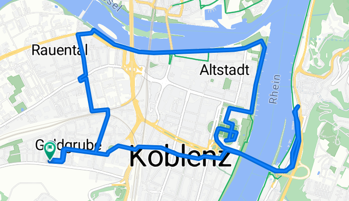
Koblenz-Goldgrube - Ehrenbreitstein (Diehl's Hotel Lounge) - Schloss - Deutsches Eck - Rauenthal - Koblenz-Goldgrube (mit Sanne).gpx
A cycling route starting in Koblenz, Rhineland-Palatinate, Germany.
Overview
About this route
TEASI track
- -:--
- Duration
- 10.4 km
- Distance
- 74 m
- Ascent
- 71 m
- Descent
- ---
- Avg. speed
- ---
- Max. altitude

Continue with Bikemap
Use, edit, or download this cycling route
You would like to ride Koblenz-Goldgrube - Ehrenbreitstein (Diehl's Hotel Lounge) - Schloss - Deutsches Eck - Rauenthal - Koblenz-Goldgrube (mit Sanne).gpx or customize it for your own trip? Here is what you can do with this Bikemap route:
Free features
- Save this route as favorite or in collections
- Copy & plan your own version of this route
- Sync your route with Garmin or Wahoo
Premium features
Free trial for 3 days, or one-time payment. More about Bikemap Premium.
- Navigate this route on iOS & Android
- Export a GPX / KML file of this route
- Create your custom printout (try it for free)
- Download this route for offline navigation
Discover more Premium features.
Get Bikemap PremiumFrom our community
Other popular routes starting in Koblenz
 Koblenz -Biedenkopf auf dem Lahnradweg
- Distance
- 223 km
- Ascent
- 573 m
- Descent
- 280 m
- Location
- Koblenz, Rhineland-Palatinate, Germany
 moseltour trier - koblenz
- Distance
- 205.6 km
- Ascent
- 554 m
- Descent
- 483 m
- Location
- Koblenz, Rhineland-Palatinate, Germany
 Mosel Thionville Mosel
- Distance
- 267 km
- Ascent
- 1,060 m
- Descent
- 989 m
- Location
- Koblenz, Rhineland-Palatinate, Germany
 Ausflug Koblenz-Winningen und zurück, 22km
- Distance
- 21.5 km
- Ascent
- 88 m
- Descent
- 90 m
- Location
- Koblenz, Rhineland-Palatinate, Germany
 RTF "Moselkarussel" 113km
- Distance
- 113.9 km
- Ascent
- 1,208 m
- Descent
- 1,168 m
- Location
- Koblenz, Rhineland-Palatinate, Germany
 Winter
- Distance
- 15.5 km
- Ascent
- 360 m
- Descent
- 360 m
- Location
- Koblenz, Rhineland-Palatinate, Germany
 Koblenz - Bad Ems
- Distance
- 16.1 km
- Ascent
- 148 m
- Descent
- 139 m
- Location
- Koblenz, Rhineland-Palatinate, Germany
 KO-Fleckertshöhe-Alken-KO
- Distance
- 77.8 km
- Ascent
- 569 m
- Descent
- 568 m
- Location
- Koblenz, Rhineland-Palatinate, Germany
Open it in the app