
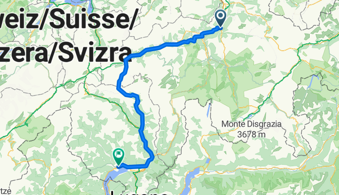
Chur - Lukmanier - Locarno
A cycling route starting in Chur, Grisons, Switzerland.
Overview
About this route
Chur - Lukmanier - Locarno
- -:--
- Duration
- 167.1 km
- Distance
- 1,615 m
- Ascent
- 2,007 m
- Descent
- ---
- Avg. speed
- ---
- Avg. speed
Route quality
Waytypes & surfaces along the route
Waytypes
Quiet road
49.6 km
(30 %)
Road
35.8 km
(21 %)
Surfaces
Paved
124.9 km
(75 %)
Unpaved
22.7 km
(14 %)
Asphalt
123.5 km
(74 %)
Gravel
17.9 km
(11 %)
Continue with Bikemap
Use, edit, or download this cycling route
You would like to ride Chur - Lukmanier - Locarno or customize it for your own trip? Here is what you can do with this Bikemap route:
Free features
- Save this route as favorite or in collections
- Copy & plan your own version of this route
- Sync your route with Garmin or Wahoo
Premium features
Free trial for 3 days, or one-time payment. More about Bikemap Premium.
- Navigate this route on iOS & Android
- Export a GPX / KML file of this route
- Create your custom printout (try it for free)
- Download this route for offline navigation
Discover more Premium features.
Get Bikemap PremiumFrom our community
Other popular routes starting in Chur
 Chur-alter Schyn-Lenzerheide-Brambrüesch-Chur
- Distance
- 63.4 km
- Ascent
- 1,481 m
- Descent
- 1,481 m
- Location
- Chur, Grisons, Switzerland
 Bündner Herrschaft
- Distance
- 82.4 km
- Ascent
- 456 m
- Descent
- 459 m
- Location
- Chur, Grisons, Switzerland
 Brambrüsch
- Distance
- 33.9 km
- Ascent
- 1,181 m
- Descent
- 1,181 m
- Location
- Chur, Grisons, Switzerland
 Runde ums Lenzerhorn
- Distance
- 99.4 km
- Ascent
- 3,444 m
- Descent
- 3,444 m
- Location
- Chur, Grisons, Switzerland
 Chur-Bündner Herrschaft-Chur
- Distance
- 70 km
- Ascent
- 419 m
- Descent
- 419 m
- Location
- Chur, Grisons, Switzerland
![[DAY 22] Chur - Eichberg](https://media.bikemap.net/routes/8579490/gallery/thumbs/42e72cd6-9c76-4f6c-9bb1-c5cb547b5f7a.jpeg.208x208_q80_crop.jpg) [DAY 22] Chur - Eichberg
[DAY 22] Chur - Eichberg- Distance
- 68.9 km
- Ascent
- 120 m
- Descent
- 195 m
- Location
- Chur, Grisons, Switzerland
 Chur - Thusis - Tiefencastel
- Distance
- 40.6 km
- Ascent
- 733 m
- Descent
- 483 m
- Location
- Chur, Grisons, Switzerland
 RR - Chur - Lenzer Heide - Albula - Julier
- Distance
- 163 km
- Ascent
- 3,409 m
- Descent
- 3,407 m
- Location
- Chur, Grisons, Switzerland
Open it in the app