
High Wycombe: Modified HWCC 50 PR Route
A cycling route starting in High Wycombe, England, United Kingdom.
Overview
About this route
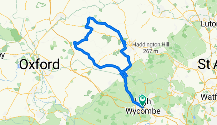
This is really a gem for High Wycombe. I've had heaps of trouble finding a nice flat route to do some long endurance work on. I've now come to the conclusion that this is probably the best. There are a few hills, but they're either short, not very steep or you'll have a strong tailwind to push you up them.
I've made one change to the route I found on High Wycombe Cycle Club's website, and that's to extend the cycle by running into Edgcott instead of going south soon after Quainton. Adds about 10km on to get me close to 100km. Roads are average and no traffic filters either, little bit windy both times I've ridden there though.
Only complaint about the route is the A4010 to Princes Risborough. The drivers are a little bit dangerous sometimes and the road quality is really poor at some stages, forcing you to ride in the middle of the road at some sections. Best idea is to go during quiet traffic times or adding going through Chesnut Way>Chinor Road and adding a few km and two hills at Stokenchurch on the way there and Aston Hill on the way back.
Takes around 3 hours to complete.
- -:--
- Duration
- 98.6 km
- Distance
- 326 m
- Ascent
- 329 m
- Descent
- ---
- Avg. speed
- ---
- Avg. speed

Continue with Bikemap
Use, edit, or download this cycling route
You would like to ride High Wycombe: Modified HWCC 50 PR Route or customize it for your own trip? Here is what you can do with this Bikemap route:
Free features
- Save this route as favorite or in collections
- Copy & plan your own version of this route
- Sync your route with Garmin or Wahoo
Premium features
Free trial for 3 days, or one-time payment. More about Bikemap Premium.
- Navigate this route on iOS & Android
- Export a GPX / KML file of this route
- Create your custom printout (try it for free)
- Download this route for offline navigation
Discover more Premium features.
Get Bikemap PremiumFrom our community
Other popular routes starting in High Wycombe
 Harriss' WCC Lockdown Route
- Distance
- 100.9 km
- Ascent
- 610 m
- Descent
- 616 m
- Location
- High Wycombe, England, United Kingdom
 West Wycombe 7/4/18
- Distance
- 16.1 km
- Ascent
- 1,522 m
- Descent
- 1,534 m
- Location
- High Wycombe, England, United Kingdom
 Eton Loop
- Distance
- 66.7 km
- Ascent
- 412 m
- Descent
- 409 m
- Location
- High Wycombe, England, United Kingdom
 Cadmore end to marlow
- Distance
- 32.4 km
- Ascent
- 321 m
- Descent
- 331 m
- Location
- High Wycombe, England, United Kingdom
 ride through High Wycombe
- Distance
- 24 km
- Ascent
- 233 m
- Descent
- 233 m
- Location
- High Wycombe, England, United Kingdom
 Lady Verney Close 18 to Lady Verney Close 19
- Distance
- 19.8 km
- Ascent
- 68 m
- Descent
- 161 m
- Location
- High Wycombe, England, United Kingdom
 Koti HW Bike Route
- Distance
- 24.6 km
- Ascent
- 233 m
- Descent
- 233 m
- Location
- High Wycombe, England, United Kingdom
 Little Kingshill & Speen Loop
- Distance
- 18.8 km
- Ascent
- 209 m
- Descent
- 213 m
- Location
- High Wycombe, England, United Kingdom
Open it in the app