

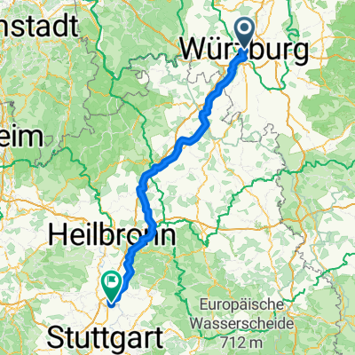
Würzburg-Ochsenfurt-Kitzingen
A cycling route starting in Wurzburg, Bavaria, Germany.
Overview
About this route
Schöne Route vom Hotel Steinburg in Würzburg entlang des Main-Radwanderweges über Ochsenfurt nach Kitzingen. Rückkehr nach Würzburg mit dem Zug möglich.
- -:--
- Duration
- 37.9 km
- Distance
- 116 m
- Ascent
- 136 m
- Descent
- ---
- Avg. speed
- 233 m
- Avg. speed
Route quality
Waytypes & surfaces along the route
Waytypes
Path
10.6 km
(28 %)
Track
6.6 km
(17 %)
Surfaces
Paved
31.5 km
(83 %)
Unpaved
0.9 km
(2 %)
Asphalt
28.3 km
(75 %)
Paving stones
1.2 km
(3 %)
Route highlights
Points of interest along the route
Point of interest after 1.7 km
Tunnel unter der Bahnlinie
Continue with Bikemap
Use, edit, or download this cycling route
You would like to ride Würzburg-Ochsenfurt-Kitzingen or customize it for your own trip? Here is what you can do with this Bikemap route:
Free features
- Save this route as favorite or in collections
- Copy & plan your own version of this route
- Sync your route with Garmin or Wahoo
Premium features
Free trial for 3 days, or one-time payment. More about Bikemap Premium.
- Navigate this route on iOS & Android
- Export a GPX / KML file of this route
- Create your custom printout (try it for free)
- Download this route for offline navigation
Discover more Premium features.
Get Bikemap PremiumFrom our community
Other popular routes starting in Wurzburg
 Rückermainstraße, Würzburg to Place de la Palud, Lausanne
- Distance
- 627.9 km
- Ascent
- 6,215 m
- Descent
- 5,892 m
- Location
- Wurzburg, Bavaria, Germany
 Würzburg über Winterhausen, Albertshausen
- Distance
- 33.2 km
- Ascent
- 188 m
- Descent
- 189 m
- Location
- Wurzburg, Bavaria, Germany
 Würzburg nach Ludwigsburg Import aus Komoot
- Distance
- 151.2 km
- Ascent
- 1,200 m
- Descent
- 1,177 m
- Location
- Wurzburg, Bavaria, Germany
 Würzburg nach Kochersteinsfeld Import aus Komoot
- Distance
- 96.8 km
- Ascent
- 1,027 m
- Descent
- 1,016 m
- Location
- Wurzburg, Bavaria, Germany
 1-Romantische Straße, Würzburg - Füssen, Teil 1 CLONED FROM ROUTE 181277
- Distance
- 105.7 km
- Ascent
- 476 m
- Descent
- 245 m
- Location
- Wurzburg, Bavaria, Germany
 Runde Höhenweg Wü Richtung Och 12xxhm
- Distance
- 56.1 km
- Ascent
- 784 m
- Descent
- 784 m
- Location
- Wurzburg, Bavaria, Germany
 Steinbachtal-H'berg-Waldbüttelbrunn-H'berg-Steinbachtal
- Distance
- 16.9 km
- Ascent
- 239 m
- Descent
- 236 m
- Location
- Wurzburg, Bavaria, Germany
 Würzburg Kochersteinsfeld über Ochsenfurt -ausgeglichen
- Distance
- 121.1 km
- Ascent
- 1,430 m
- Descent
- 1,418 m
- Location
- Wurzburg, Bavaria, Germany
Open it in the app