

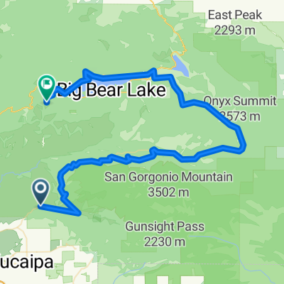
38 mile Yucaipa/Redlands/Highland loop
A cycling route starting in Yucaipa, California, United States of America.
Overview
About this route
Base mile loop
- -:--
- Duration
- 62.5 km
- Distance
- 666 m
- Ascent
- 666 m
- Descent
- ---
- Avg. speed
- ---
- Avg. speed
Route quality
Waytypes & surfaces along the route
Waytypes
Busy road
38.8 km
(62 %)
Road
11 km
(18 %)
Surfaces
Paved
21 km
(34 %)
Asphalt
19.1 km
(30 %)
Concrete
1.6 km
(3 %)
Continue with Bikemap
Use, edit, or download this cycling route
You would like to ride 38 mile Yucaipa/Redlands/Highland loop or customize it for your own trip? Here is what you can do with this Bikemap route:
Free features
- Save this route as favorite or in collections
- Copy & plan your own version of this route
- Sync your route with Garmin or Wahoo
Premium features
Free trial for 3 days, or one-time payment. More about Bikemap Premium.
- Navigate this route on iOS & Android
- Export a GPX / KML file of this route
- Create your custom printout (try it for free)
- Download this route for offline navigation
Discover more Premium features.
Get Bikemap PremiumFrom our community
Other popular routes starting in Yucaipa
 half way to bear and back
- Distance
- 72.5 km
- Ascent
- 1,551 m
- Descent
- 1,571 m
- Location
- Yucaipa, California, United States of America
 38 mile Yucaipa/Redlands/Highland loop
- Distance
- 62.5 km
- Ascent
- 666 m
- Descent
- 666 m
- Location
- Yucaipa, California, United States of America
 r202 ROAM
- Distance
- 86.5 km
- Ascent
- 1,898 m
- Descent
- 956 m
- Location
- Yucaipa, California, United States of America
 Blistering ride in Palm Springs
- Distance
- 68.5 km
- Ascent
- 3,010 m
- Descent
- 3,720 m
- Location
- Yucaipa, California, United States of America
 29-Mountain Home to Aguanga
- Distance
- 138.4 km
- Ascent
- 1,664 m
- Descent
- 2,166 m
- Location
- Yucaipa, California, United States of America
 35465 Beech Ave, Yucaipa to 35465 Beech Ave, Yucaipa
- Distance
- 11.4 km
- Ascent
- 167 m
- Descent
- 168 m
- Location
- Yucaipa, California, United States of America
 Yucaipa Hills
- Distance
- 16.8 km
- Ascent
- 239 m
- Descent
- 239 m
- Location
- Yucaipa, California, United States of America
 Onyx Summit
- Distance
- 98.2 km
- Ascent
- 1,982 m
- Descent
- 2,014 m
- Location
- Yucaipa, California, United States of America
Open it in the app