

Tomislavgrad _ Rama
A cycling route starting in Tomislavgrad, Federation of Bosnia and Herzegovina, Bosnia and Herzegovina.
Overview
About this route
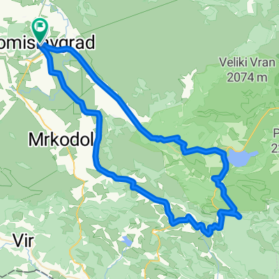
Tomislavgrad-Rama-Kupres
- -:--
- Duration
- 135.9 km
- Distance
- 1,839 m
- Ascent
- 1,830 m
- Descent
- ---
- Avg. speed
- ---
- Avg. speed

Route quality
Waytypes & surfaces along the route
Waytypes
Busy road
116.1 km
(85 %)
Quiet road
14.5 km
(11 %)
Surfaces
Paved
121.5 km
(89 %)
Asphalt
120.1 km
(88 %)
Paved (undefined)
1.5 km
(1 %)
Undefined
14.4 km
(11 %)
Continue with Bikemap
Use, edit, or download this cycling route
You would like to ride Tomislavgrad _ Rama or customize it for your own trip? Here is what you can do with this Bikemap route:
Free features
- Save this route as favorite or in collections
- Copy & plan your own version of this route
- Sync your route with Garmin or Wahoo
Premium features
Free trial for 3 days, or one-time payment. More about Bikemap Premium.
- Navigate this route on iOS & Android
- Export a GPX / KML file of this route
- Create your custom printout (try it for free)
- Download this route for offline navigation
Discover more Premium features.
Get Bikemap PremiumFrom our community
Other popular routes starting in Tomislavgrad
 TG-Tribistovo
- Distance
- 75.1 km
- Ascent
- 618 m
- Descent
- 619 m
- Location
- Tomislavgrad, Federation of Bosnia and Herzegovina, Bosnia and Herzegovina
 Tomislavgrad-Split
- Distance
- 108.1 km
- Ascent
- 721 m
- Descent
- 1,613 m
- Location
- Tomislavgrad, Federation of Bosnia and Herzegovina, Bosnia and Herzegovina
 Recovered Route
- Distance
- 24.3 km
- Ascent
- 76 m
- Descent
- 64 m
- Location
- Tomislavgrad, Federation of Bosnia and Herzegovina, Bosnia and Herzegovina
 Oko Buškog jezera 1.0
- Distance
- 57.8 km
- Ascent
- 763 m
- Descent
- 747 m
- Location
- Tomislavgrad, Federation of Bosnia and Herzegovina, Bosnia and Herzegovina
 Farma Smiljanić-Kukavičje jezero
- Distance
- 56.7 km
- Ascent
- 408 m
- Descent
- 411 m
- Location
- Tomislavgrad, Federation of Bosnia and Herzegovina, Bosnia and Herzegovina
 TG-Studena-Rakitno-Blidinje-TG
- Distance
- 78.3 km
- Ascent
- 901 m
- Descent
- 905 m
- Location
- Tomislavgrad, Federation of Bosnia and Herzegovina, Bosnia and Herzegovina
 Tusnica Vitrenik
- Distance
- 49.9 km
- Ascent
- 1,226 m
- Descent
- 1,226 m
- Location
- Tomislavgrad, Federation of Bosnia and Herzegovina, Bosnia and Herzegovina
 YU 002: Tomislavgrad - Mostar
- Distance
- 91.9 km
- Ascent
- 1,330 m
- Descent
- 2,163 m
- Location
- Tomislavgrad, Federation of Bosnia and Herzegovina, Bosnia and Herzegovina
Open it in the app