

Katzenstein-Tour 01
A cycling route starting in Wildenfels, Saxony, Germany.
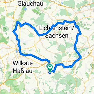
Overview
About this route
...abwechslungsreiche Strecke: Straße, Feld- und Waldwege, verschiedener Untergrund
Im Hartensteiner Wald gibts mehrere Varianten.
- -:--
- Duration
- 55.4 km
- Distance
- 877 m
- Ascent
- 856 m
- Descent
- ---
- Avg. speed
- 625 m
- Max. altitude
Route quality
Waytypes & surfaces along the route
Waytypes
Track
22.8 km
(41 %)
Quiet road
15.4 km
(28 %)
Surfaces
Paved
30.6 km
(55 %)
Unpaved
17.9 km
(32 %)
Asphalt
28 km
(50 %)
Ground
6.9 km
(12 %)
Route highlights
Points of interest along the route

Point of interest after 23.6 km
Höchster Punkt des Katzenstein (627m).
Continue with Bikemap
Use, edit, or download this cycling route
You would like to ride Katzenstein-Tour 01 or customize it for your own trip? Here is what you can do with this Bikemap route:
Free features
- Save this route as favorite or in collections
- Copy & plan your own version of this route
- Sync your route with Garmin or Wahoo
Premium features
Free trial for 3 days, or one-time payment. More about Bikemap Premium.
- Navigate this route on iOS & Android
- Export a GPX / KML file of this route
- Create your custom printout (try it for free)
- Download this route for offline navigation
Discover more Premium features.
Get Bikemap PremiumFrom our community
Other popular routes starting in Wildenfels
 Lindenallee 30, Wildenfels nach Lindenallee 45, Wildenfels
- Distance
- 12.6 km
- Ascent
- 271 m
- Descent
- 313 m
- Location
- Wildenfels, Saxony, Germany
 Lindenallee nach Lindenallee
- Distance
- 188.3 km
- Ascent
- 788 m
- Descent
- 840 m
- Location
- Wildenfels, Saxony, Germany
 Hermannsdorfer Straße 62, Langenweißbach nach Falkenweg 8, Langenweißbach
- Distance
- 29.7 km
- Ascent
- 522 m
- Descent
- 530 m
- Location
- Wildenfels, Saxony, Germany
 Auersberg-Tour 01
- Distance
- 65.8 km
- Ascent
- 1,274 m
- Descent
- 1,090 m
- Location
- Wildenfels, Saxony, Germany
 Schulberg 4, Wildenfels nach Schulberg 4, Wildenfels
- Distance
- 22.1 km
- Ascent
- 380 m
- Descent
- 381 m
- Location
- Wildenfels, Saxony, Germany
 Lindenallee nach Lindenallee
- Distance
- 0.5 km
- Ascent
- 43 m
- Descent
- 47 m
- Location
- Wildenfels, Saxony, Germany
 Lindenallee 47, Wildenfels nach Lindenallee 43, Wildenfels
- Distance
- 122.3 km
- Ascent
- 454 m
- Descent
- 445 m
- Location
- Wildenfels, Saxony, Germany
 Kirchberg-Irfersgrün-Treuen
- Distance
- 29.2 km
- Ascent
- 499 m
- Descent
- 326 m
- Location
- Wildenfels, Saxony, Germany
Open it in the app