Premium Badge Download on the App Store Get it on Google Play Turn-by-turn Navigation Offline Maps Bike Type Optimized Routing Premium Maps Custom Bike Computer Export Routes Route Previews Fall Detection Premium Support

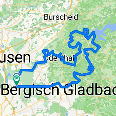
Cycling Route in Mülheim, North Rhine-Westphalia, Germany

Super schöne Schloss Burg Tagestour.

4
Open this route in the Bikemap app

Open this route in the Bikemap app

Open this route in Bikemap Web

Open this route in Bikemap Web

86 km
Distance
832 m
Ascent
834 m
Descent
-:-- h
Duration
-- km/h
Avg. Speed
--- m
Max. Elevation

About This Route

Das Bild zeigt einen Brunnen in Odentahl.  Der Besitzer ist außerdem ein sehr handwerklicher Geselle. Zu sehen sind geteiltreue Nachbildungen aus Holz wie der Kölner bzw. Altenberger Dom als auch eine Vielzahl von berühmten Schiffen. Und vieles mehr.

Die Tour führt über Dünnwald,Schlebusch,Uppersberg,Engstenberg, Glöbusch,Odentahl,Altenberg,Hüttchen,Dhünntalsperre,Bremen, Hilgen, Senkbachtalsperre, Höhrath,Schloss Burg,Witzhelden,Altenbach, Wersbach,Burscheid, Haus Landscheid,Versuchs Gut Höfchen,Altenberger Märchenwald,Blecher, Glöbusch,Schildgen,Paffrath, Dünnwald.


This cycling route is ideal for: MTB

You will cycle on the following surfaces: Paved Unpaved Gravel

Customize this cycling route with the Bikemap route planner.

Make it yours!

Did you know? You can use this route as a template in our cycling route planner if you don't wish to start from scratch. Customize it based on your needs to plan your perfect cycling tour.

Open it in the app