

yes!
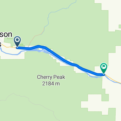
A cycling route starting in Thompson Falls, Montana, United States of America.
Overview
About this route
- -:--
- Duration
- 41.9 km
- Distance
- 374 m
- Ascent
- 336 m
- Descent
- ---
- Avg. speed
- ---
- Avg. speed
Continue with Bikemap
Use, edit, or download this cycling route
You would like to ride yes! or customize it for your own trip? Here is what you can do with this Bikemap route:
Free features
- Save this route as favorite or in collections
- Copy & plan your own version of this route
- Sync your route with Garmin or Wahoo
Premium features
Free trial for 3 days, or one-time payment. More about Bikemap Premium.
- Navigate this route on iOS & Android
- Export a GPX / KML file of this route
- Create your custom printout (try it for free)
- Download this route for offline navigation
Discover more Premium features.
Get Bikemap PremiumFrom our community
Other popular routes starting in Thompson Falls
 Thompson Falls to Fairfield
- Distance
- 190.9 km
- Ascent
- 1,364 m
- Descent
- 1,361 m
- Location
- Thompson Falls, Montana, United States of America
 yes!
yes!- Distance
- 41.9 km
- Ascent
- 374 m
- Descent
- 336 m
- Location
- Thompson Falls, Montana, United States of America
 5468 MT-200, Thompson Falls to 6777–6799 MT-200, Plains
- Distance
- 21.8 km
- Ascent
- 119 m
- Descent
- 145 m
- Location
- Thompson Falls, Montana, United States of America
 6 clark fk - missoula
- Distance
- 161.8 km
- Ascent
- 976 m
- Descent
- 793 m
- Location
- Thompson Falls, Montana, United States of America
Open it in the app