

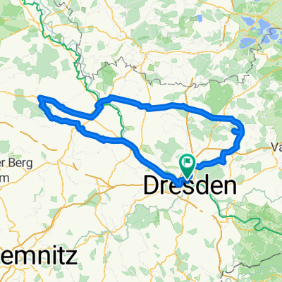
Dresden-Glashütte
A cycling route starting in Dresden, Saxony, Germany.
Overview
About this route
- -:--
- Duration
- 56.2 km
- Distance
- 532 m
- Ascent
- 531 m
- Descent
- ---
- Avg. speed
- ---
- Avg. speed
Route highlights
Points of interest along the route
Point of interest after 0.6 km
Point of interest after 1.5 km
Point of interest after 3.5 km
Point of interest after 5 km
Point of interest after 6.2 km
Point of interest after 11.4 km
Point of interest after 16.9 km
Point of interest after 18.6 km
Point of interest after 22.2 km
Point of interest after 24.2 km
Point of interest after 29 km
Point of interest after 33.7 km
Point of interest after 35.4 km
Point of interest after 38.4 km
Point of interest after 43.7 km
Point of interest after 45.4 km
Point of interest after 47.1 km
Point of interest after 49.7 km
Point of interest after 50.6 km
Point of interest after 52.5 km
Continue with Bikemap
Use, edit, or download this cycling route
You would like to ride Dresden-Glashütte or customize it for your own trip? Here is what you can do with this Bikemap route:
Free features
- Save this route as favorite or in collections
- Copy & plan your own version of this route
- Sync your route with Garmin or Wahoo
Premium features
Free trial for 3 days, or one-time payment. More about Bikemap Premium.
- Navigate this route on iOS & Android
- Export a GPX / KML file of this route
- Create your custom printout (try it for free)
- Download this route for offline navigation
Discover more Premium features.
Get Bikemap PremiumFrom our community
Other popular routes starting in Dresden
 Strecke - Erdgas Race Day-Speed-Challenge 2009
- Distance
- 63.4 km
- Ascent
- 515 m
- Descent
- 496 m
- Location
- Dresden, Saxony, Germany
 DD-Collm-Riesa-Keulenberg-DD
- Distance
- 196.8 km
- Ascent
- 1,000 m
- Descent
- 904 m
- Location
- Dresden, Saxony, Germany
 SachsenEnergie-Tour
- Distance
- 46.8 km
- Ascent
- 125 m
- Descent
- 120 m
- Location
- Dresden, Saxony, Germany
 Dresden - Altenberg
- Distance
- 52.7 km
- Ascent
- 1,016 m
- Descent
- 385 m
- Location
- Dresden, Saxony, Germany
 Rennradrunde um den Tharandter Wald
- Distance
- 78.9 km
- Ascent
- 934 m
- Descent
- 850 m
- Location
- Dresden, Saxony, Germany
 cielab.org - Dresden - Bahratal - Mückentürmchen
- Distance
- 130 km
- Ascent
- 1,524 m
- Descent
- 1,516 m
- Location
- Dresden, Saxony, Germany
 Fahrrad XXL-Tour
- Distance
- 109.7 km
- Ascent
- 1,387 m
- Descent
- 1,383 m
- Location
- Dresden, Saxony, Germany
 Panometer-Tour
- Distance
- 7.7 km
- Ascent
- 15 m
- Descent
- 13 m
- Location
- Dresden, Saxony, Germany
Open it in the app