

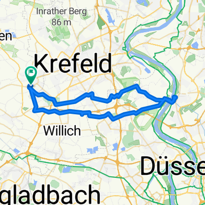
Vorst-Dülken
A cycling route starting in Tönisvorst, North Rhine-Westphalia, Germany.
Overview
About this route
von Vorst nach Dülken an den Süchtelner Höhen vorbei
- -:--
- Duration
- 21.7 km
- Distance
- 53 m
- Ascent
- 34 m
- Descent
- ---
- Avg. speed
- ---
- Avg. speed
Route quality
Waytypes & surfaces along the route
Waytypes
Quiet road
13.4 km
(62 %)
Track
5.5 km
(26 %)
Surfaces
Paved
14.6 km
(67 %)
Unpaved
2.4 km
(11 %)
Asphalt
14.4 km
(66 %)
Gravel
1.8 km
(8 %)
Continue with Bikemap
Use, edit, or download this cycling route
You would like to ride Vorst-Dülken or customize it for your own trip? Here is what you can do with this Bikemap route:
Free features
- Save this route as favorite or in collections
- Copy & plan your own version of this route
- Sync your route with Garmin or Wahoo
Premium features
Free trial for 3 days, or one-time payment. More about Bikemap Premium.
- Navigate this route on iOS & Android
- Export a GPX / KML file of this route
- Create your custom printout (try it for free)
- Download this route for offline navigation
Discover more Premium features.
Get Bikemap PremiumFrom our community
Other popular routes starting in Tönisvorst
 Kleiner und Großer De Wittsee – Bahntrasse Runde von Forsthaus
- Distance
- 64.3 km
- Ascent
- 122 m
- Descent
- 125 m
- Location
- Tönisvorst, North Rhine-Westphalia, Germany
 Niederrhein-3
- Distance
- 46.7 km
- Ascent
- 58 m
- Descent
- 57 m
- Location
- Tönisvorst, North Rhine-Westphalia, Germany
 Rund um Hüls
- Distance
- 24 km
- Ascent
- 53 m
- Descent
- 53 m
- Location
- Tönisvorst, North Rhine-Westphalia, Germany
 Von St.Tönis auf ein Eis nach Süchteln
- Distance
- 32.4 km
- Ascent
- 26 m
- Descent
- 28 m
- Location
- Tönisvorst, North Rhine-Westphalia, Germany
 Anrath-Vorst-Kempen-Grefrath-Süchteln
- Distance
- 49 km
- Ascent
- 27 m
- Descent
- 29 m
- Location
- Tönisvorst, North Rhine-Westphalia, Germany
 Staubwolke Fischeln 09 Sommertraining
- Distance
- 57.8 km
- Ascent
- 55 m
- Descent
- 60 m
- Location
- Tönisvorst, North Rhine-Westphalia, Germany
 Niederrhein-2
- Distance
- 29.4 km
- Ascent
- 9 m
- Descent
- 9 m
- Location
- Tönisvorst, North Rhine-Westphalia, Germany
 Von St.Tönis über Kaldenkirchen und zurück
- Distance
- 68.7 km
- Ascent
- 115 m
- Descent
- 119 m
- Location
- Tönisvorst, North Rhine-Westphalia, Germany
Open it in the app