
Grafing - Alxing - Glonn - Moosach - Grafing
A cycling route starting in Grafing bei München, Bavaria, Germany.
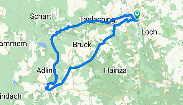
Overview
About this route
Längere Radltour mit größerer Steigung zwischen Alxing und Glonn
- -:--
- Duration
- 26.6 km
- Distance
- 172 m
- Ascent
- 169 m
- Descent
- ---
- Avg. speed
- ---
- Avg. speed
Route quality
Waytypes & surfaces along the route
Waytypes
Road
7.8 km
(29 %)
Quiet road
6.7 km
(25 %)
Surfaces
Paved
22.1 km
(83 %)
Unpaved
4.3 km
(16 %)
Asphalt
21.6 km
(81 %)
Gravel
3.2 km
(12 %)
Continue with Bikemap
Use, edit, or download this cycling route
You would like to ride Grafing - Alxing - Glonn - Moosach - Grafing or customize it for your own trip? Here is what you can do with this Bikemap route:
Free features
- Save this route as favorite or in collections
- Copy & plan your own version of this route
- Sync your route with Garmin or Wahoo
Premium features
Free trial for 3 days, or one-time payment. More about Bikemap Premium.
- Navigate this route on iOS & Android
- Export a GPX / KML file of this route
- Create your custom printout (try it for free)
- Download this route for offline navigation
Discover more Premium features.
Get Bikemap PremiumFrom our community
Other popular routes starting in Grafing bei München
 Kurze Feierabend-Runde
- Distance
- 17.2 km
- Ascent
- 193 m
- Descent
- 188 m
- Location
- Grafing bei München, Bavaria, Germany
 18.06.03 Ludwigstour
- Distance
- 34.4 km
- Ascent
- 127 m
- Descent
- 128 m
- Location
- Grafing bei München, Bavaria, Germany
 11.08.11 Kaffeeradltour um Grafing
- Distance
- 21 km
- Ascent
- 150 m
- Descent
- 150 m
- Location
- Grafing bei München, Bavaria, Germany
 SKG lang 9: Grafing-Pasing; 73,9km 210hm
- Distance
- 73.9 km
- Ascent
- 260 m
- Descent
- 256 m
- Location
- Grafing bei München, Bavaria, Germany
 10.07.08 Kaffetour zur Schießstätte
- Distance
- 27.7 km
- Ascent
- 278 m
- Descent
- 280 m
- Location
- Grafing bei München, Bavaria, Germany
 Strassenrunde -Grafing-Beyharting-Grafing
- Distance
- 41.8 km
- Ascent
- 304 m
- Descent
- 305 m
- Location
- Grafing bei München, Bavaria, Germany
 18.08.15 Kalteneckfahrt
- Distance
- 36.2 km
- Ascent
- 263 m
- Descent
- 262 m
- Location
- Grafing bei München, Bavaria, Germany
 10.07.06 nach Frauenneuharting
- Distance
- 25.3 km
- Ascent
- 226 m
- Descent
- 227 m
- Location
- Grafing bei München, Bavaria, Germany
Open it in the app