

Villach - Florenz / Tag 2
A cycling route starting in Pontebba, Friuli Venezia Giulia, Italy.
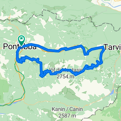
Overview
About this route
Pontebba - Gemona del Friuli - Rivoli - San Daniele del Friuli - Dignano - Überquerung des Fiume Tagliamento - Provesano - Rauscedo - Zoppola - Pordenone
- -:--
- Duration
- 103.5 km
- Distance
- 50 m
- Ascent
- 603 m
- Descent
- ---
- Avg. speed
- ---
- Avg. speed

Route quality
Waytypes & surfaces along the route
Waytypes
Quiet road
39.4 km
(38 %)
Busy road
34 km
(33 %)
Surfaces
Paved
62.4 km
(60 %)
Unpaved
1.4 km
(1 %)
Asphalt
62.4 km
(60 %)
Gravel
0.8 km
(<1 %)
Continue with Bikemap
Use, edit, or download this cycling route
You would like to ride Villach - Florenz / Tag 2 or customize it for your own trip? Here is what you can do with this Bikemap route:
Free features
- Save this route as favorite or in collections
- Copy & plan your own version of this route
- Sync your route with Garmin or Wahoo
Premium features
Free trial for 3 days, or one-time payment. More about Bikemap Premium.
- Navigate this route on iOS & Android
- Export a GPX / KML file of this route
- Create your custom printout (try it for free)
- Download this route for offline navigation
Discover more Premium features.
Get Bikemap PremiumFrom our community
Other popular routes starting in Pontebba
 TE Pontebba, Nassfeld, Tarvisio, Pontebba
- Distance
- 97.2 km
- Ascent
- 1,811 m
- Descent
- 1,804 m
- Location
- Pontebba, Friuli Venezia Giulia, Italy
 Pontebba fino a Dongna con i bambini
- Distance
- 22.9 km
- Ascent
- 473 m
- Descent
- 466 m
- Location
- Pontebba, Friuli Venezia Giulia, Italy
 Pontebba-Sella Nevea-Arnoldstein
- Distance
- 63.3 km
- Ascent
- 893 m
- Descent
- 889 m
- Location
- Pontebba, Friuli Venezia Giulia, Italy
 Alpe-Adria Pontebba - Villach
- Distance
- 60.9 km
- Ascent
- 720 m
- Descent
- 763 m
- Location
- Pontebba, Friuli Venezia Giulia, Italy
 malga poccet rifugio grego lussari
- Distance
- 76.4 km
- Ascent
- 2,563 m
- Descent
- 2,562 m
- Location
- Pontebba, Friuli Venezia Giulia, Italy
 2. nap Pontebba-Udine B. verzió (bicóutas)
- Distance
- 77.9 km
- Ascent
- 956 m
- Descent
- 1,405 m
- Location
- Pontebba, Friuli Venezia Giulia, Italy
 Pontebba-Pramollo-Monte Croce-Cason di Lanza
- Distance
- 120.9 km
- Ascent
- 3,191 m
- Descent
- 3,191 m
- Location
- Pontebba, Friuli Venezia Giulia, Italy
 Piazza Giuseppe Garibaldi 4, Pontebba do Piazza Giuseppe Garibaldi 4, Pontebba
- Distance
- 50.2 km
- Ascent
- 501 m
- Descent
- 479 m
- Location
- Pontebba, Friuli Venezia Giulia, Italy
Open it in the app