
Orchideenwanderung bei Niederehe
A cycling route starting in Nohn, Rhineland-Palatinate, Germany.
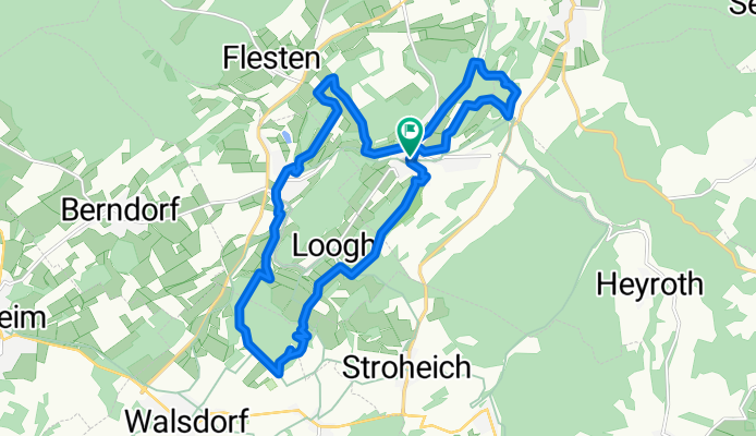
Overview
About this route
TEASI track
- -:--
- Duration
- 17.5 km
- Distance
- 396 m
- Ascent
- 396 m
- Descent
- ---
- Avg. speed
- ---
- Avg. speed

Route quality
Waytypes & surfaces along the route
Waytypes
Track
11.2 km
(64 %)
Path
4.5 km
(26 %)
Surfaces
Paved
1.8 km
(10 %)
Unpaved
13.9 km
(79 %)
Ground
8.4 km
(48 %)
Gravel
2.2 km
(13 %)
Continue with Bikemap
Use, edit, or download this cycling route
You would like to ride Orchideenwanderung bei Niederehe or customize it for your own trip? Here is what you can do with this Bikemap route:
Free features
- Save this route as favorite or in collections
- Copy & plan your own version of this route
- Sync your route with Garmin or Wahoo
Premium features
Free trial for 3 days, or one-time payment. More about Bikemap Premium.
- Navigate this route on iOS & Android
- Export a GPX / KML file of this route
- Create your custom printout (try it for free)
- Download this route for offline navigation
Discover more Premium features.
Get Bikemap PremiumFrom our community
Other popular routes starting in Nohn
 Stroheicher Straße 1, Üxheim nach Loogher Straße 7, Üxheim
- Distance
- 20.9 km
- Ascent
- 237 m
- Descent
- 248 m
- Location
- Nohn, Rhineland-Palatinate, Germany
 wasserfall
- Distance
- 10.1 km
- Ascent
- 200 m
- Descent
- 206 m
- Location
- Nohn, Rhineland-Palatinate, Germany
 Nohn - Trier
- Distance
- 106 km
- Ascent
- 405 m
- Descent
- 664 m
- Location
- Nohn, Rhineland-Palatinate, Germany
 Hauptstraße 4, Nohn nach Graf-Mirbach-Platz 8, Hillesheim
- Distance
- 12.2 km
- Ascent
- 104 m
- Descent
- 135 m
- Location
- Nohn, Rhineland-Palatinate, Germany
 Üxheim-Ormont-Üxheim
- Distance
- 88.9 km
- Ascent
- 876 m
- Descent
- 876 m
- Location
- Nohn, Rhineland-Palatinate, Germany
 Gemütliche Route in Nohn
- Distance
- 14.9 km
- Ascent
- 339 m
- Descent
- 342 m
- Location
- Nohn, Rhineland-Palatinate, Germany
 Tag 5 Kalkofen bis Drais-Brück
- Distance
- 7.6 km
- Ascent
- 255 m
- Descent
- 169 m
- Location
- Nohn, Rhineland-Palatinate, Germany
 Hammermühle - Manderscheid
- Distance
- 97.4 km
- Ascent
- 1,081 m
- Descent
- 1,009 m
- Location
- Nohn, Rhineland-Palatinate, Germany
Open it in the app