
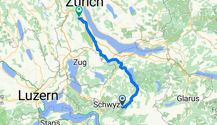
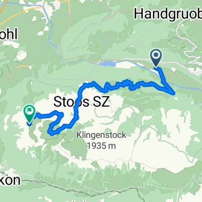
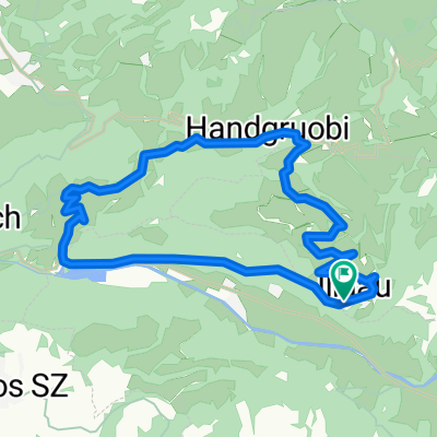
Ibergeregg - Einsiedeln - Hirzel - Leimbach
A cycling route starting in Muotathal, Canton of Schwyz, Switzerland.
Overview
About this route
- 3 h 38 min
- Duration
- 55.7 km
- Distance
- 180 m
- Ascent
- 1,093 m
- Descent
- 15.3 km/h
- Avg. speed
- ---
- Avg. speed
Route quality
Waytypes & surfaces along the route
Waytypes
Busy road
22.5 km
(40 %)
Quiet road
13.7 km
(25 %)
Surfaces
Paved
36.8 km
(66 %)
Unpaved
0.1 km
(<1 %)
Asphalt
36.3 km
(65 %)
Paving stones
0.4 km
(<1 %)
Continue with Bikemap
Use, edit, or download this cycling route
You would like to ride Ibergeregg - Einsiedeln - Hirzel - Leimbach or customize it for your own trip? Here is what you can do with this Bikemap route:
Free features
- Save this route as favorite or in collections
- Copy & plan your own version of this route
- Sync your route with Garmin or Wahoo
Premium features
Free trial for 3 days, or one-time payment. More about Bikemap Premium.
- Navigate this route on iOS & Android
- Export a GPX / KML file of this route
- Create your custom printout (try it for free)
- Download this route for offline navigation
Discover more Premium features.
Get Bikemap PremiumFrom our community
Other popular routes starting in Muotathal
 Schächental Bike
- Distance
- 55.9 km
- Ascent
- 1,916 m
- Descent
- 1,739 m
- Location
- Muotathal, Canton of Schwyz, Switzerland
 Route im Schneckentempo in Glarus
- Distance
- 18.9 km
- Ascent
- 69 m
- Descent
- 1,109 m
- Location
- Muotathal, Canton of Schwyz, Switzerland
 Stoos
Stoos- Distance
- 12.4 km
- Ascent
- 1,346 m
- Descent
- 19 m
- Location
- Muotathal, Canton of Schwyz, Switzerland
 Muotathal - Uznach - Küsnacht
- Distance
- 97.1 km
- Ascent
- 1,430 m
- Descent
- 1,604 m
- Location
- Muotathal, Canton of Schwyz, Switzerland
 Einsiedeln-Ibergeregg-Pragel-Schwialppass-Sattelegg
- Distance
- 74.4 km
- Ascent
- 2,266 m
- Descent
- 2,264 m
- Location
- Muotathal, Canton of Schwyz, Switzerland
 Illgau - Aufiberg
- Distance
- 14.8 km
- Ascent
- 630 m
- Descent
- 630 m
- Location
- Muotathal, Canton of Schwyz, Switzerland
 W/Muotathal gross
- Distance
- 17.4 km
- Ascent
- 843 m
- Descent
- 791 m
- Location
- Muotathal, Canton of Schwyz, Switzerland
 Klausenpass Rückfahrt
- Distance
- 166.7 km
- Ascent
- 1,495 m
- Descent
- 2,929 m
- Location
- Muotathal, Canton of Schwyz, Switzerland
Open it in the app