

Kleines Prebischtor
A cycling route starting in Sebnitz, Saxony, Germany.
Overview
About this route
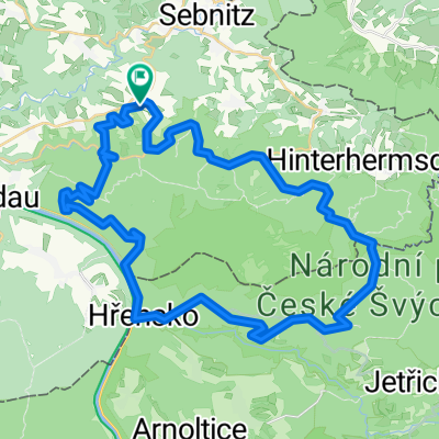
Von Lichtenhain geht es zum Lichtenhainer Wasserfall ins Kirnitzschtal. Hierfahren wir abwärts nach Bad Schandau. Auf dem Elberadweg gelangen wir nach Schmilka. Auf der Straße kommen wir über die Grenze (trotz Schengen sollten Ausweisdokumente mitgeführt werden) nach Böhmen (Ceska Republika). In Herrnskretschen (Hrensko) biegen wir links ab und Fahren die Straße hinauf nach Rainwiese (Mezna Louka). Nach etwa 1 km verlassen wir die Straße, um auf dem mit der Radwegenummer 3030 gekennzeichneten, steilen Weg weiterzufahren. An der Passhöhe können wir einen Abstecher (als Wanderung) zum sog. Kleinen Prebischtor (Mala Pravcicka Brana) einbauen. Als Etapenpunkt sollte der ehemalige Flecken Hinterdittersbach (Zadni Jetrichovice) im Auge behalten werden, die Radwegenummer 3030 geleitet uns dahin. Das damalige Hinterdittersbach liegt direkt an der Grenze zu Sachsen an der Kirnitzsch und umfasste eine Handvoll Gebäude mit mehreren Wirtshäusern. Heute sind nur noch Grundmauern auszumachen. Weiter geht es wahrhaft idyllisch für einige Kilometer am Fluss entlang. Kurz vor der Buschmühle (Ghs.) treffen wir auf die Autostraße, auf der wir bis zum Lichtenhainer Wasserfall weiterfahren. Zurück nach Lichtenhain kommen wir auf der Wasserfallstraße.
- -:--
- Duration
- 46.6 km
- Distance
- 735 m
- Ascent
- 804 m
- Descent
- ---
- Avg. speed
- 357 m
- Avg. speed

Route quality
Waytypes & surfaces along the route
Waytypes
Track
16.2 km
(35 %)
Busy road
14.5 km
(31 %)
Surfaces
Paved
37.9 km
(81 %)
Unpaved
6.1 km
(13 %)
Asphalt
36 km
(77 %)
Gravel
5.4 km
(12 %)
Continue with Bikemap
Use, edit, or download this cycling route
You would like to ride Kleines Prebischtor or customize it for your own trip? Here is what you can do with this Bikemap route:
Free features
- Save this route as favorite or in collections
- Copy & plan your own version of this route
- Sync your route with Garmin or Wahoo
Premium features
Free trial for 3 days, or one-time payment. More about Bikemap Premium.
- Navigate this route on iOS & Android
- Export a GPX / KML file of this route
- Create your custom printout (try it for free)
- Download this route for offline navigation
Discover more Premium features.
Get Bikemap PremiumFrom our community
Other popular routes starting in Sebnitz
 Zwischen Kirnitzschtal und Balzhütten
- Distance
- 38 km
- Ascent
- 415 m
- Descent
- 415 m
- Location
- Sebnitz, Saxony, Germany
 Sächsische-Böhmische-Schweiz - Runde
- Distance
- 42.5 km
- Ascent
- 394 m
- Descent
- 394 m
- Location
- Sebnitz, Saxony, Germany
 Zeughaus, Zeidlertal, Tanzplan
- Distance
- 46.2 km
- Ascent
- 696 m
- Descent
- 697 m
- Location
- Sebnitz, Saxony, Germany
 110 km Sparkassen Panorama- RADtour
- Distance
- 101.1 km
- Ascent
- 1,097 m
- Descent
- 1,097 m
- Location
- Sebnitz, Saxony, Germany
 Hinterhermsdorf-Panoramaweg-Bad Schandau-Nationalpark
- Distance
- 46.1 km
- Ascent
- 693 m
- Descent
- 693 m
- Location
- Sebnitz, Saxony, Germany
 Panoramatour Sächsische Schweiz
- Distance
- 56.3 km
- Ascent
- 581 m
- Descent
- 581 m
- Location
- Sebnitz, Saxony, Germany
 Hinterhermsdorf - Ruppersdorf
- Distance
- 65.6 km
- Ascent
- 571 m
- Descent
- 618 m
- Location
- Sebnitz, Saxony, Germany
 Kleines Prebischtor, Var. 2
- Distance
- 46.8 km
- Ascent
- 586 m
- Descent
- 586 m
- Location
- Sebnitz, Saxony, Germany
Open it in the app