![[Tour Francia 2001 - Et. 11] Grenoble - Chamrousse](/_next/static/media/contour-lines-light-small.cafd5e5d.avif)
![[Tour Francia 2001 - Et. 11] Grenoble - Chamrousse](https://media.bikemap.net/routes/312364/staticmaps/in_dea063aa-d4b7-44b2-915f-03fc60acb0dc_694x400_bikemap-2021-3D-static.png)
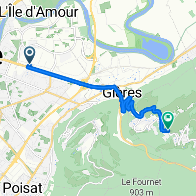
[Tour Francia 2001 - Et. 11] Grenoble - Chamrousse
A cycling route starting in Saint-Martin-d'Hères, Auvergne-Rhône-Alpes, France.
Overview
About this route
<span style="color: #000000; font-family: 'Times New Roman'; font-size: medium;"> <div style="background-image: initial; background-repeat: initial; background-attachment: initial; -webkit-background-clip: initial; -webkit-background-origin: initial; background-color: #ffffff; color: #535353; font-family: Verdana, Arial, Helvetica, sans-serif; font-size: 10px; background-position: initial initial; margin: 8px;">
Undecima etapa (cronoescalada) del Tour de Francia de 2001 con salida en Grenoble y llegada en Chamrousse. </div> </span>
- -:--
- Duration
- 32 km
- Distance
- 1,603 m
- Ascent
- 137 m
- Descent
- ---
- Avg. speed
- ---
- Avg. speed

Continue with Bikemap
Use, edit, or download this cycling route
You would like to ride [Tour Francia 2001 - Et. 11] Grenoble - Chamrousse or customize it for your own trip? Here is what you can do with this Bikemap route:
Free features
- Save this route as favorite or in collections
- Copy & plan your own version of this route
- Sync your route with Garmin or Wahoo
Premium features
Free trial for 3 days, or one-time payment. More about Bikemap Premium.
- Navigate this route on iOS & Android
- Export a GPX / KML file of this route
- Create your custom printout (try it for free)
- Download this route for offline navigation
Discover more Premium features.
Get Bikemap PremiumFrom our community
Other popular routes starting in Saint-Martin-d'Hères
 Grenoble - Val Pelouse
- Distance
- 155.4 km
- Ascent
- 5,934 m
- Descent
- 4,465 m
- Location
- Saint-Martin-d'Hères, Auvergne-Rhône-Alpes, France
 venon
venon- Distance
- 5.8 km
- Ascent
- 374 m
- Descent
- 50 m
- Location
- Saint-Martin-d'Hères, Auvergne-Rhône-Alpes, France
 Montée Chamrousse depuis Grenoble
- Distance
- 67.1 km
- Ascent
- 1,571 m
- Descent
- 1,571 m
- Location
- Saint-Martin-d'Hères, Auvergne-Rhône-Alpes, France
 De 106 Avenue Marcel Cachin, Saint-Martin-d'Hères à Avenue Marcel Cachin, Saint-Martin-d'Hères
- Distance
- 23.8 km
- Ascent
- 293 m
- Descent
- 292 m
- Location
- Saint-Martin-d'Hères, Auvergne-Rhône-Alpes, France
 Tavernolles - Arkéma
- Distance
- 31.1 km
- Ascent
- 377 m
- Descent
- 377 m
- Location
- Saint-Martin-d'Hères, Auvergne-Rhône-Alpes, France
 Clémencière + Palaquit
- Distance
- 36.8 km
- Ascent
- 1,045 m
- Descent
- 1,045 m
- Location
- Saint-Martin-d'Hères, Auvergne-Rhône-Alpes, France
 Tour Belledonne par Villard-Bonnot
- Distance
- 52.1 km
- Ascent
- 880 m
- Descent
- 878 m
- Location
- Saint-Martin-d'Hères, Auvergne-Rhône-Alpes, France
 Wanna be at the white house on the top ;)
- Distance
- 27.2 km
- Ascent
- 2,013 m
- Descent
- 22 m
- Location
- Saint-Martin-d'Hères, Auvergne-Rhône-Alpes, France
Open it in the app