Premium Badge Download on the App Store Get it on Google Play Turn-by-turn Navigation Offline Maps Bike Type Optimized Routing Premium Maps Custom Bike Computer Export Routes Route Previews Fall Detection Premium Support

Cycling Route in Myślenice, Lesser Poland Voivodeship, Poland

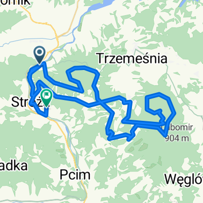
Matus: Myślenice-Kudłacze-Poręba-trzemeśnia-Bulina

0
Open this route in the Bikemap app

Open this route in the Bikemap app

Open this route in Bikemap Web

Open this route in Bikemap Web

32 km
Distance
809 m
Ascent
811 m
Descent
-:-- h
Duration
-- km/h
Avg. Speed
--- m
Max. Elevation

About This Route

Trasa w cieniu dobra na upały, dużo szutry i szlaków, mało asfaltu.

Z buta odcinku 500m, +ew pod schronisko na Kudłaczach.

Start z parkingu koło boiska, pocżatkowo aslaft, potem od szlabanu szutrówą na Bulinę, potem na Chełm, Kudłacze następnie zjazd do Przełęczy Suchej nastęnię szutruwą do Poręby, dalej asfalt do stacji OMEGA, tam w lewo. Po zjechaniu z góry na skrzyżowaniu zjechać z głównej w lewo.. na betony i znowu na Bulinę. Tu można sobie zmodyfikować trasę pojechać na wprost, lub skręcić w prawo czerwonym do szlabanów i tam znowu albo w dół do parkingu, albo jak u mnie na mapie na Zarabie.


This cycling route is ideal for: MTB

You will cycle on the following surfaces: Paved Unpaved

Customize this cycling route with the Bikemap route planner.

Make it yours!

Did you know? You can use this route as a template in our cycling route planner if you don't wish to start from scratch. Customize it based on your needs to plan your perfect cycling tour.

Open it in the app