

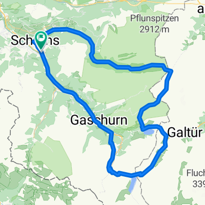
Schruns Ludesch Frastanz Nenzing
A cycling route starting in Schruns, Vorarlberg, Austria.
Overview
About this route
Sehr schöne Tour . Nur gabz kurz Kiesweg
- -:--
- Duration
- 48.7 km
- Distance
- 82 m
- Ascent
- 256 m
- Descent
- ---
- Avg. speed
- ---
- Avg. speed

Route quality
Waytypes & surfaces along the route
Waytypes
Quiet road
17.8 km
(37 %)
Path
11.9 km
(25 %)
Surfaces
Paved
44.7 km
(92 %)
Unpaved
2.9 km
(6 %)
Asphalt
44.4 km
(91 %)
Gravel
1.5 km
(3 %)
Route highlights
Points of interest along the route

Photo after 41 km

Photo after 43.3 km

Photo after 44.7 km
Nachbauersee baden verboten
Continue with Bikemap
Use, edit, or download this cycling route
You would like to ride Schruns Ludesch Frastanz Nenzing or customize it for your own trip? Here is what you can do with this Bikemap route:
Free features
- Save this route as favorite or in collections
- Copy & plan your own version of this route
- Sync your route with Garmin or Wahoo
Premium features
Free trial for 3 days, or one-time payment. More about Bikemap Premium.
- Navigate this route on iOS & Android
- Export a GPX / KML file of this route
- Create your custom printout (try it for free)
- Download this route for offline navigation
Discover more Premium features.
Get Bikemap PremiumFrom our community
Other popular routes starting in Schruns
 Vandans - Schweizer Tor - Lindauer Hütte
- Distance
- 35.4 km
- Ascent
- 1,680 m
- Descent
- 1,687 m
- Location
- Schruns, Vorarlberg, Austria
 schruns partenen heilbronner hütte silbertal schruns
- Distance
- 75.7 km
- Ascent
- 2,289 m
- Descent
- 2,290 m
- Location
- Schruns, Vorarlberg, Austria
 Schruns-Saarbrücker hütte
- Distance
- 69.1 km
- Ascent
- 1,871 m
- Descent
- 1,875 m
- Location
- Schruns, Vorarlberg, Austria
 Rund um den Itonskopf Tour
- Distance
- 24.4 km
- Ascent
- 1,319 m
- Descent
- 916 m
- Location
- Schruns, Vorarlberg, Austria
 Tschagguns - Latschau - Vadans - Schruns
- Distance
- 24.6 km
- Ascent
- 984 m
- Descent
- 986 m
- Location
- Schruns, Vorarlberg, Austria
 MeHC 2023
- Distance
- 9.9 km
- Ascent
- 1,174 m
- Descent
- 6 m
- Location
- Schruns, Vorarlberg, Austria
 Silvretta-Hochalpenstraße und Arlbergpaß RR
- Distance
- 138.8 km
- Ascent
- 2,371 m
- Descent
- 2,371 m
- Location
- Schruns, Vorarlberg, Austria
 M fit Montafon Mountainbike Marathon
- Distance
- 29.4 km
- Ascent
- 377 m
- Descent
- 377 m
- Location
- Schruns, Vorarlberg, Austria
Open it in the app