

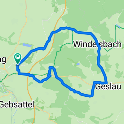
Tauberradweg Rothenburg nach Apfelbach und zurück
A cycling route starting in Rothenburg upon Tauber, Bavaria, Germany.
Overview
About this route
Mit dem Auto nach Rothenburg ob der Tauber und von dort mit den Rad den Tauberradweg nach Merkelsheim und Apfelbach und zurück nach Rothenburg
- -:--
- Duration
- 93.7 km
- Distance
- 663 m
- Ascent
- 663 m
- Descent
- ---
- Avg. speed
- ---
- Avg. speed
Route quality
Waytypes & surfaces along the route
Waytypes
Quiet road
33.8 km
(36 %)
Track
29.2 km
(31 %)
Surfaces
Paved
73.8 km
(79 %)
Unpaved
0.3 km
(<1 %)
Asphalt
62.7 km
(67 %)
Paved (undefined)
10.3 km
(11 %)
Continue with Bikemap
Use, edit, or download this cycling route
You would like to ride Tauberradweg Rothenburg nach Apfelbach und zurück or customize it for your own trip? Here is what you can do with this Bikemap route:
Free features
- Save this route as favorite or in collections
- Copy & plan your own version of this route
- Sync your route with Garmin or Wahoo
Premium features
Free trial for 3 days, or one-time payment. More about Bikemap Premium.
- Navigate this route on iOS & Android
- Export a GPX / KML file of this route
- Create your custom printout (try it for free)
- Download this route for offline navigation
Discover more Premium features.
Get Bikemap PremiumFrom our community
Other popular routes starting in Rothenburg upon Tauber
 Altmühlradweg: Rothenburg-Kelheim
- Distance
- 244.8 km
- Ascent
- 316 m
- Descent
- 400 m
- Location
- Rothenburg upon Tauber, Bavaria, Germany
 Taubertal-Panorama
- Distance
- 52.4 km
- Ascent
- 733 m
- Descent
- 895 m
- Location
- Rothenburg upon Tauber, Bavaria, Germany
 Rothenburg-Tauberquelle
- Distance
- 44.7 km
- Ascent
- 278 m
- Descent
- 278 m
- Location
- Rothenburg upon Tauber, Bavaria, Germany
 Rothenburg to Bamberg
- Distance
- 120.8 km
- Ascent
- 98 m
- Descent
- 285 m
- Location
- Rothenburg upon Tauber, Bavaria, Germany
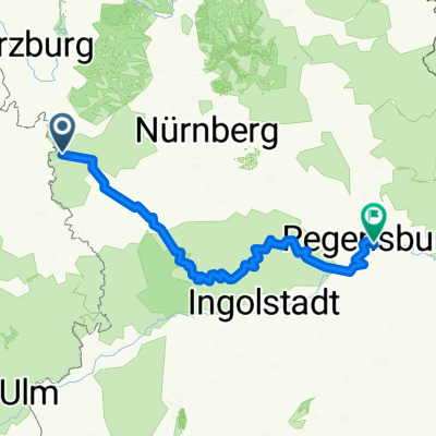 Rothenburg-Regensburg
- Distance
- 263.4 km
- Ascent
- 1,292 m
- Descent
- 1,373 m
- Location
- Rothenburg upon Tauber, Bavaria, Germany
 Frankenhöhe
- Distance
- 25 km
- Ascent
- 219 m
- Descent
- 224 m
- Location
- Rothenburg upon Tauber, Bavaria, Germany
 Paneuropa radweg (alternative german part)
- Distance
- 36 km
- Ascent
- 498 m
- Descent
- 580 m
- Location
- Rothenburg upon Tauber, Bavaria, Germany
 altmühltal
- Distance
- 137.4 km
- Ascent
- 496 m
- Descent
- 540 m
- Location
- Rothenburg upon Tauber, Bavaria, Germany
Open it in the app