
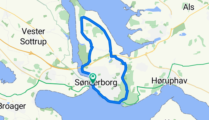
Sønderborg Kommune - 22 km Sønderborg
A cycling route starting in Sønderborg, Region South Denmark, Denmark.
Overview
About this route
Tips:
Hvis man vil undgå grusvej så kør fortsætad Borgmester Andersensvej/Friheds Allé til Ringgade hvorder drejes til venstre mod Lystbådhavnen. Ellers grusvej fra km 17 til 21, hvis der køres med uret rundt.
Udsigtspunkter:
Sønderborg Havn (km. 0-2)
Arnkil (km. 10-12)
Sønderskoven (km. 19-22)
Før musen hen over højdekurven for at se kilometerpunkter.
- -:--
- Duration
- 22 km
- Distance
- 59 m
- Ascent
- 60 m
- Descent
- ---
- Avg. speed
- 20 m
- Avg. speed
Route quality
Waytypes & surfaces along the route
Waytypes
Road
7.2 km
(33 %)
Quiet road
5.7 km
(26 %)
Surfaces
Paved
17.7 km
(80 %)
Unpaved
4.1 km
(18 %)
Asphalt
17.6 km
(80 %)
Gravel
2.9 km
(13 %)
Continue with Bikemap
Use, edit, or download this cycling route
You would like to ride Sønderborg Kommune - 22 km Sønderborg or customize it for your own trip? Here is what you can do with this Bikemap route:
Free features
- Save this route as favorite or in collections
- Copy & plan your own version of this route
- Sync your route with Garmin or Wahoo
Premium features
Free trial for 3 days, or one-time payment. More about Bikemap Premium.
- Navigate this route on iOS & Android
- Export a GPX / KML file of this route
- Create your custom printout (try it for free)
- Download this route for offline navigation
Discover more Premium features.
Get Bikemap PremiumFrom our community
Other popular routes starting in Sønderborg
 Lille rund tur på als
- Distance
- 52 km
- Ascent
- 173 m
- Descent
- 170 m
- Location
- Sønderborg, Region South Denmark, Denmark
 detour to work #2
- Distance
- 10.7 km
- Ascent
- 101 m
- Descent
- 93 m
- Location
- Sønderborg, Region South Denmark, Denmark
 Onsdagstræningsrute for Sønderborg Cykle Klub 2009
- Distance
- 97.5 km
- Ascent
- 322 m
- Descent
- 325 m
- Location
- Sønderborg, Region South Denmark, Denmark
 Færgeturen
- Distance
- 104.5 km
- Ascent
- 321 m
- Descent
- 316 m
- Location
- Sønderborg, Region South Denmark, Denmark
 Um Soenderborg
- Distance
- 35 km
- Ascent
- 129 m
- Descent
- 111 m
- Location
- Sønderborg, Region South Denmark, Denmark
 Skovvej 22E, Sønderborg to Kløvermarken 2, Sønderborg
- Distance
- 15.9 km
- Ascent
- 41 m
- Descent
- 42 m
- Location
- Sønderborg, Region South Denmark, Denmark
 Sløjfe 1B - Kær Halvø
- Distance
- 23 km
- Ascent
- 81 m
- Descent
- 87 m
- Location
- Sønderborg, Region South Denmark, Denmark
 broager gendarm
- Distance
- 22.1 km
- Ascent
- 406 m
- Descent
- 434 m
- Location
- Sønderborg, Region South Denmark, Denmark
Open it in the app