
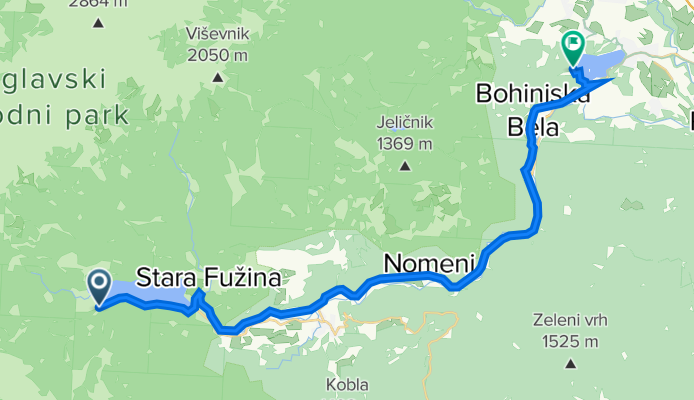
Bohinj - Bled
A cycling route starting in Bohinjska Bistrica, Bohinj, Slovenia.
Overview
About this route
Bohinj - Bled
- -:--
- Duration
- 30.7 km
- Distance
- 209 m
- Ascent
- 261 m
- Descent
- ---
- Avg. speed
- ---
- Avg. speed

Route quality
Waytypes & surfaces along the route
Waytypes
Busy road
13.1 km
(43 %)
Quiet road
8.3 km
(27 %)
Surfaces
Paved
30.1 km
(98 %)
Unpaved
0.1 km
(<1 %)
Asphalt
29.7 km
(97 %)
Paved (undefined)
0.3 km
(1 %)
Continue with Bikemap
Use, edit, or download this cycling route
You would like to ride Bohinj - Bled or customize it for your own trip? Here is what you can do with this Bikemap route:
Free features
- Save this route as favorite or in collections
- Copy & plan your own version of this route
- Sync your route with Garmin or Wahoo
Premium features
Free trial for 3 days, or one-time payment. More about Bikemap Premium.
- Navigate this route on iOS & Android
- Export a GPX / KML file of this route
- Create your custom printout (try it for free)
- Download this route for offline navigation
Discover more Premium features.
Get Bikemap PremiumFrom our community
Other popular routes starting in Bohinjska Bistrica
 Stara Fužina - Planina Vogar - Stara Fužina
- Distance
- 20.7 km
- Ascent
- 819 m
- Descent
- 826 m
- Location
- Bohinjska Bistrica, Bohinj, Slovenia
 Day 2 Side Trip to Waterfall Savica
- Distance
- 15.6 km
- Ascent
- 337 m
- Descent
- 339 m
- Location
- Bohinjska Bistrica, Bohinj, Slovenia
 Day 2 Side Trip to Waterfall Savica
- Distance
- 7.8 km
- Ascent
- 239 m
- Descent
- 112 m
- Location
- Bohinjska Bistrica, Bohinj, Slovenia
 Bohinj-Nova Gorica
- Distance
- 105.8 km
- Ascent
- 4,715 m
- Descent
- 5,135 m
- Location
- Bohinjska Bistrica, Bohinj, Slovenia
 Bohinjske sedlo and Koprivnik
- Distance
- 52.4 km
- Ascent
- 1,335 m
- Descent
- 1,335 m
- Location
- Bohinjska Bistrica, Bohinj, Slovenia
 Podbrdo-Nova Gorica
- Distance
- 68.5 km
- Ascent
- 2,632 m
- Descent
- 3,042 m
- Location
- Bohinjska Bistrica, Bohinj, Slovenia
 2025. Bledi-tó-Ljubljana-Celje teljes
- Distance
- 173 km
- Ascent
- 2,965 m
- Descent
- 3,443 m
- Location
- Bohinjska Bistrica, Bohinj, Slovenia
 Bohinjska Bistrica do Češnjice, okoli jezera in na slap
- Distance
- 32.5 km
- Ascent
- 332 m
- Descent
- 329 m
- Location
- Bohinjska Bistrica, Bohinj, Slovenia
Open it in the app