

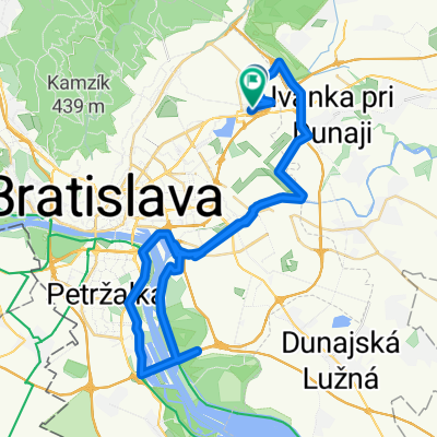
Vajnory - Biely Kriz - Pod Kozi chrbat - Limbach
A cycling route starting in Bratislava - Vajnory, Bratislavský kraj, Slovak Republic.
Overview
About this route
for MTB even if most of the time it was on the road
- -:--
- Duration
- 44.6 km
- Distance
- 1,038 m
- Ascent
- 1,035 m
- Descent
- ---
- Avg. speed
- 558 m
- Avg. speed

Route quality
Waytypes & surfaces along the route
Waytypes
Track
18 km
(40 %)
Road
9.7 km
(22 %)
Surfaces
Paved
26.2 km
(59 %)
Unpaved
9 km
(20 %)
Asphalt
25.6 km
(57 %)
Unpaved (undefined)
7.6 km
(17 %)
Continue with Bikemap
Use, edit, or download this cycling route
You would like to ride Vajnory - Biely Kriz - Pod Kozi chrbat - Limbach or customize it for your own trip? Here is what you can do with this Bikemap route:
Free features
- Save this route as favorite or in collections
- Copy & plan your own version of this route
- Sync your route with Garmin or Wahoo
Premium features
Free trial for 3 days, or one-time payment. More about Bikemap Premium.
- Navigate this route on iOS & Android
- Export a GPX / KML file of this route
- Create your custom printout (try it for free)
- Download this route for offline navigation
Discover more Premium features.
Get Bikemap PremiumFrom our community
Other popular routes starting in Bratislava - Vajnory
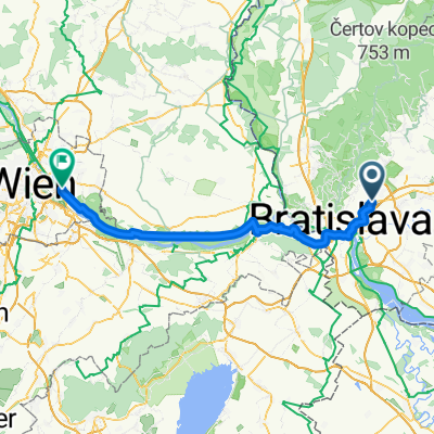 7. Bratislava-Vienna
- Distance
- 72.5 km
- Ascent
- 269 m
- Descent
- 233 m
- Location
- Bratislava - Vajnory, Bratislavský kraj, Slovak Republic
 Rača - Rača 2
- Distance
- 21.5 km
- Ascent
- 440 m
- Descent
- 441 m
- Location
- Bratislava - Vajnory, Bratislavský kraj, Slovak Republic
 Pekná cesta - Biely kríž - Štefánikova mohyla
- Distance
- 46.6 km
- Ascent
- 1,607 m
- Descent
- 1,619 m
- Location
- Bratislava - Vajnory, Bratislavský kraj, Slovak Republic
 Pri vinohradoch 9799/269E, Bratislava až Pri starom letisku, Vajnory
- Distance
- 32.5 km
- Ascent
- 60 m
- Descent
- 84 m
- Location
- Bratislava - Vajnory, Bratislavský kraj, Slovak Republic
 Vajnorske jazera . Vrakuna . most D4 - Rusovce - Prístavný most- Vlcie hrdlo a spat
- Distance
- 64.1 km
- Ascent
- 49 m
- Descent
- 50 m
- Location
- Bratislava - Vajnory, Bratislavský kraj, Slovak Republic
 Rača Biely kríž
- Distance
- 4.7 km
- Ascent
- 338 m
- Descent
- 0 m
- Location
- Bratislava - Vajnory, Bratislavský kraj, Slovak Republic
 Long ride from Bratislava to Lednice
- Distance
- 756.5 km
- Ascent
- 2,236 m
- Descent
- 2,207 m
- Location
- Bratislava - Vajnory, Bratislavský kraj, Slovak Republic
 Haimburg_Berg_01
- Distance
- 61.9 km
- Ascent
- 151 m
- Descent
- 150 m
- Location
- Bratislava - Vajnory, Bratislavský kraj, Slovak Republic
Open it in the app