

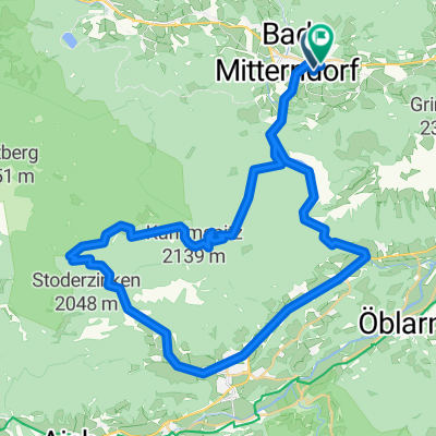
Viehbergalmrunde
A cycling route starting in Tauplitz, Styria, Austria.
Overview
About this route
Traumhafte Runde mit Highligt in den "Öfen"
- -:--
- Duration
- 45 km
- Distance
- 874 m
- Ascent
- 1,058 m
- Descent
- ---
- Avg. speed
- ---
- Avg. speed
Route quality
Waytypes & surfaces along the route
Waytypes
Track
18 km
(40 %)
Quiet road
11.5 km
(25 %)
Surfaces
Paved
18.7 km
(42 %)
Unpaved
17.2 km
(38 %)
Asphalt
17.7 km
(39 %)
Gravel
17.1 km
(38 %)
Continue with Bikemap
Use, edit, or download this cycling route
You would like to ride Viehbergalmrunde or customize it for your own trip? Here is what you can do with this Bikemap route:
Free features
- Save this route as favorite or in collections
- Copy & plan your own version of this route
- Sync your route with Garmin or Wahoo
Premium features
Free trial for 3 days, or one-time payment. More about Bikemap Premium.
- Navigate this route on iOS & Android
- Export a GPX / KML file of this route
- Create your custom printout (try it for free)
- Download this route for offline navigation
Discover more Premium features.
Get Bikemap PremiumFrom our community
Other popular routes starting in Tauplitz
 Tauplitzalm - Grundlsee - Bad Mitterndorf - Tauplitzalm
- Distance
- 50.9 km
- Ascent
- 1,271 m
- Descent
- 1,271 m
- Location
- Tauplitz, Styria, Austria
 Thörl 3 nach Kurhausplatz 63, Bad Aussee
- Distance
- 31.9 km
- Ascent
- 454 m
- Descent
- 627 m
- Location
- Tauplitz, Styria, Austria
 Salzkammergut Radroute 1. Tag
- Distance
- 53.7 km
- Ascent
- 269 m
- Descent
- 576 m
- Location
- Tauplitz, Styria, Austria
 Tauplitz
- Distance
- 29.2 km
- Ascent
- 715 m
- Descent
- 1,565 m
- Location
- Tauplitz, Styria, Austria
 Bad Mitterndorf
- Distance
- 47.8 km
- Ascent
- 939 m
- Descent
- 936 m
- Location
- Tauplitz, Styria, Austria
 2020_Bad Mitterndorf-Grundlsee-Weissenbachalm-Mitterndorf
- Distance
- 59.3 km
- Ascent
- 1,180 m
- Descent
- 1,180 m
- Location
- Tauplitz, Styria, Austria
 Bad Mittendorf_VeihbergalmGROBMING-Salzastausee_BM_45_990
- Distance
- 45.3 km
- Ascent
- 958 m
- Descent
- 958 m
- Location
- Tauplitz, Styria, Austria
 Okolo Ödensee
- Distance
- 43.7 km
- Ascent
- 643 m
- Descent
- 643 m
- Location
- Tauplitz, Styria, Austria
Open it in the app