

Wanderung Kickelhahn
A cycling route starting in Schmiedefeld am Rennsteig, Free State of Thuringia, Germany.
Overview
About this route
Mit dem Zug zum Bahnhof Rennsteig
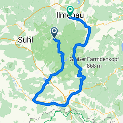
Bahnhof Rennsteig - Auerhahn - Kickelhahn - Manebach - Ilmenau Bad- -:--
- Duration
- 17.1 km
- Distance
- 341 m
- Ascent
- 589 m
- Descent
- ---
- Avg. speed
- ---
- Avg. speed

Route highlights
Points of interest along the route

Photo after 2.4 km
Erste Rast

Photo after 4.5 km
Auf der Wiese ...

Photo after 4.6 km
Kneipp-Armbad

Photo after 5.7 km
Auerhahn

Photo after 7.5 km
Hirtenwiese

Photo after 8.4 km
Klanghölzer

Photo after 9.1 km

Photo after 9.8 km
Kickelhahn

Photo after 10.3 km
hallo ...

Photo after 11 km
Aufstieg zum Hermannstein
Continue with Bikemap
Use, edit, or download this cycling route
You would like to ride Wanderung Kickelhahn or customize it for your own trip? Here is what you can do with this Bikemap route:
Free features
- Save this route as favorite or in collections
- Copy & plan your own version of this route
- Sync your route with Garmin or Wahoo
Premium features
Free trial for 3 days, or one-time payment. More about Bikemap Premium.
- Navigate this route on iOS & Android
- Export a GPX / KML file of this route
- Create your custom printout (try it for free)
- Download this route for offline navigation
Discover more Premium features.
Get Bikemap PremiumFrom our community
Other popular routes starting in Schmiedefeld am Rennsteig
 Ilmtal-Radweg
- Distance
- 119.8 km
- Ascent
- 116 m
- Descent
- 747 m
- Location
- Schmiedefeld am Rennsteig, Free State of Thuringia, Germany
 Thüringer Wald Vessertal Rund um Schmiedefeld am rennsteig
- Distance
- 37.7 km
- Ascent
- 626 m
- Descent
- 626 m
- Location
- Schmiedefeld am Rennsteig, Free State of Thuringia, Germany
 Crux-Wegscheide-Stutenhaus
- Distance
- 14 km
- Ascent
- 275 m
- Descent
- 277 m
- Location
- Schmiedefeld am Rennsteig, Free State of Thuringia, Germany
 Ilmtal-Radweg
- Distance
- 0.3 km
- Ascent
- 0 m
- Descent
- 12 m
- Location
- Schmiedefeld am Rennsteig, Free State of Thuringia, Germany
 RSSL_2012_6
- Distance
- 19.6 km
- Ascent
- 402 m
- Descent
- 321 m
- Location
- Schmiedefeld am Rennsteig, Free State of Thuringia, Germany
 2016-09-03: Bhf Rennsteig - Arnstadt
- Distance
- 84 km
- Ascent
- 391 m
- Descent
- 867 m
- Location
- Schmiedefeld am Rennsteig, Free State of Thuringia, Germany
 Knüllfeld und zurück
- Distance
- 55.3 km
- Ascent
- 1,073 m
- Descent
- 1,070 m
- Location
- Schmiedefeld am Rennsteig, Free State of Thuringia, Germany
 2018-06-09: Bhf Rennsteig - Werra-Quelle
- Distance
- 96.3 km
- Ascent
- 802 m
- Descent
- 1,075 m
- Location
- Schmiedefeld am Rennsteig, Free State of Thuringia, Germany
Open it in the app