
RadelThon-Stuttgart
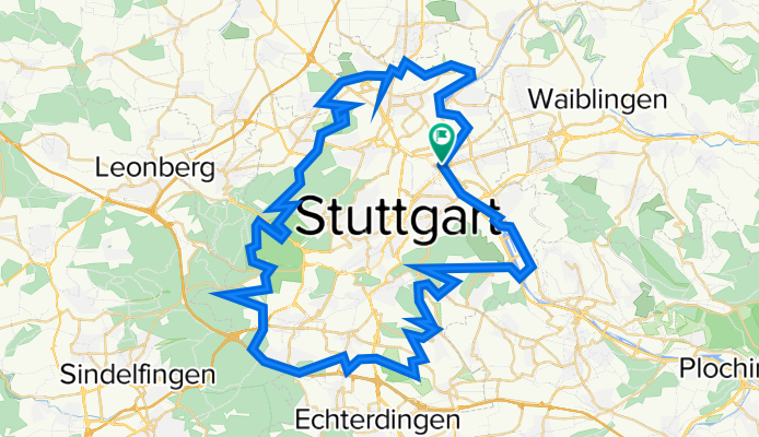
A cycling route starting in Stuttgart-Ost, Baden-Württemberg, Germany.
Overview
About this route
80km rund um Stuttgart. Weg ist als Radel Thon ausgeschildert. Normale Richtung: Gegen Uhrzeigersinn.
- -:--
- Duration
- 80 km
- Distance
- 633 m
- Ascent
- 634 m
- Descent
- ---
- Avg. speed
- ---
- Avg. speed

Route quality
Waytypes & surfaces along the route
Waytypes
Track
39.7 km
(50 %)
Quiet road
13.4 km
(17 %)
Surfaces
Paved
50.2 km
(63 %)
Unpaved
23.7 km
(30 %)
Asphalt
47.1 km
(59 %)
Loose gravel
14 km
(18 %)
Continue with Bikemap
Use, edit, or download this cycling route
You would like to ride RadelThon-Stuttgart or customize it for your own trip? Here is what you can do with this Bikemap route:
Free features
- Save this route as favorite or in collections
- Copy & plan your own version of this route
- Sync your route with Garmin or Wahoo
Premium features
Free trial for 3 days, or one-time payment. More about Bikemap Premium.
- Navigate this route on iOS & Android
- Export a GPX / KML file of this route
- Create your custom printout (try it for free)
- Download this route for offline navigation
Discover more Premium features.
Get Bikemap PremiumFrom our community
Other popular routes starting in Stuttgart-Ost
 Radtour WHBLT Dienstag
- Distance
- 64.7 km
- Ascent
- 1,274 m
- Descent
- 1,274 m
- Location
- Stuttgart-Ost, Baden-Württemberg, Germany
 Rössleweg
- Distance
- 56.2 km
- Ascent
- 778 m
- Descent
- 778 m
- Location
- Stuttgart-Ost, Baden-Württemberg, Germany
 Radel-Thon
- Distance
- 80.1 km
- Ascent
- 624 m
- Descent
- 624 m
- Location
- Stuttgart-Ost, Baden-Württemberg, Germany
 rotenberg - lederberg - zollberg
- Distance
- 40.6 km
- Ascent
- 647 m
- Descent
- 625 m
- Location
- Stuttgart-Ost, Baden-Württemberg, Germany
 siebenmühlental
- Distance
- 49.2 km
- Ascent
- 513 m
- Descent
- 508 m
- Location
- Stuttgart-Ost, Baden-Württemberg, Germany
 BC - RT (3) - 98K
- Distance
- 98.5 km
- Ascent
- 0 m
- Descent
- 0 m
- Location
- Stuttgart-Ost, Baden-Württemberg, Germany
 Feierabendrunde
- Distance
- 39.1 km
- Ascent
- 494 m
- Descent
- 466 m
- Location
- Stuttgart-Ost, Baden-Württemberg, Germany
 schnelle runde
- Distance
- 46.5 km
- Ascent
- 522 m
- Descent
- 457 m
- Location
- Stuttgart-Ost, Baden-Württemberg, Germany