

Eagles Route Downhill
A cycling route starting in Chiang Mai, Chiang Mai Province, Thailand.
Overview
About this route
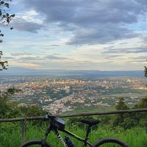
This is probably the easiest downhill route from Doi Pui. It starts near Doi Pui summit. The first few km are paved. The road then transitions into unpaved double track; shortly after that there is the hilltribe coffee shop which offers great mountain views and homegrown coffee. The entire trail is fairly steep and requires sensible brake use. The upper part is frequented by cars and motorcycles, so be careful. The trail ends at Huay Tueng Tao lake, which is ideal for a lunch/dinner break or for taking a swim.
There are three options to get your bike up Doi Pui: pedalling up Sriwichai Rd., pushing it up the (shorter) hiking trails, or taking a taxi from the zoo at Huay Kaeow Rd.(cloned from route 1995180)
- -:--
- Duration
- 18.3 km
- Distance
- 301 m
- Ascent
- 1,467 m
- Descent
- ---
- Avg. speed
- ---
- Avg. speed
Continue with Bikemap
Use, edit, or download this cycling route
You would like to ride Eagles Route Downhill or customize it for your own trip? Here is what you can do with this Bikemap route:
Free features
- Save this route as favorite or in collections
- Copy & plan your own version of this route
- Sync your route with Garmin or Wahoo
Premium features
Free trial for 3 days, or one-time payment. More about Bikemap Premium.
- Navigate this route on iOS & Android
- Export a GPX / KML file of this route
- Create your custom printout (try it for free)
- Download this route for offline navigation
Discover more Premium features.
Get Bikemap PremiumFrom our community
Other popular routes starting in Chiang Mai
 MTCM - ITT Huay Tung Thao Lake
- Distance
- 8.3 km
- Ascent
- 72 m
- Descent
- 78 m
- Location
- Chiang Mai, Chiang Mai Province, Thailand
 Reverse Samoeng Loop back via Bhubbing Palace
- Distance
- 116.8 km
- Ascent
- 2,847 m
- Descent
- 2,847 m
- Location
- Chiang Mai, Chiang Mai Province, Thailand
 straight to samoeng
- Distance
- 41.2 km
- Ascent
- 1,028 m
- Descent
- 849 m
- Location
- Chiang Mai, Chiang Mai Province, Thailand
 Phuping Palace
- Distance
- 52.2 km
- Ascent
- 1,083 m
- Descent
- 1,098 m
- Location
- Chiang Mai, Chiang Mai Province, Thailand
 Cycle in Thai 03 : Chiang Rai, Myanmar
- Distance
- 263.6 km
- Ascent
- 781 m
- Descent
- 703 m
- Location
- Chiang Mai, Chiang Mai Province, Thailand
 Chiangmai U to Doi Su Thep view point
- Distance
- 18.1 km
- Ascent
- 404 m
- Descent
- 403 m
- Location
- Chiang Mai, Chiang Mai Province, Thailand
 Chiang Mai - Rim Ping
- Distance
- 65 km
- Ascent
- 30 m
- Descent
- 29 m
- Location
- Chiang Mai, Chiang Mai Province, Thailand
 MHS Loop
- Distance
- 533.7 km
- Ascent
- 5,294 m
- Descent
- 5,289 m
- Location
- Chiang Mai, Chiang Mai Province, Thailand
Open it in the app