

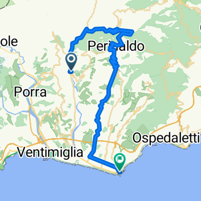
Testa d'Alpe - VTT
A cycling route starting in Dolceacqua, Liguria, Italy.
Overview
About this route
Paved road but uncertain section requires MTB
- -:--
- Duration
- 48.7 km
- Distance
- 1,367 m
- Ascent
- 1,369 m
- Descent
- ---
- Avg. speed
- ---
- Max. altitude
Route quality
Waytypes & surfaces along the route
Waytypes
Track
21.9 km
(45 %)
Road
15.6 km
(32 %)
Surfaces
Paved
14.1 km
(29 %)
Unpaved
19.5 km
(40 %)
Asphalt
14.1 km
(29 %)
Gravel
12.7 km
(26 %)
Continue with Bikemap
Use, edit, or download this cycling route
You would like to ride Testa d'Alpe - VTT or customize it for your own trip? Here is what you can do with this Bikemap route:
Free features
- Save this route as favorite or in collections
- Copy & plan your own version of this route
- Sync your route with Garmin or Wahoo
Premium features
Free trial for 3 days, or one-time payment. More about Bikemap Premium.
- Navigate this route on iOS & Android
- Export a GPX / KML file of this route
- Create your custom printout (try it for free)
- Download this route for offline navigation
Discover more Premium features.
Get Bikemap PremiumFrom our community
Other popular routes starting in Dolceacqua
 Route from Via Provinciale 34, Dolceacqua
- Distance
- 102.7 km
- Ascent
- 1,393 m
- Descent
- 1,393 m
- Location
- Dolceacqua, Liguria, Italy
 Gravel Alpes maritimes Italie - Trucco
- Distance
- 60.3 km
- Ascent
- 1,920 m
- Descent
- 1,915 m
- Location
- Dolceacqua, Liguria, Italy
 Testa d'Alpe - VTT
- Distance
- 48.7 km
- Ascent
- 1,367 m
- Descent
- 1,369 m
- Location
- Dolceacqua, Liguria, Italy
 2018 et3y
- Distance
- 98.9 km
- Ascent
- 3,054 m
- Descent
- 2,354 m
- Location
- Dolceacqua, Liguria, Italy
 Route to Dolceacqua
- Distance
- 38.1 km
- Ascent
- 1,950 m
- Descent
- 1,950 m
- Location
- Dolceacqua, Liguria, Italy
 Pigna Bajardo
- Distance
- 86.4 km
- Ascent
- 1,930 m
- Descent
- 1,932 m
- Location
- Dolceacqua, Liguria, Italy
 Piazza Padre Giovanni Mauro, Dolceacqua nach Corso Francesco Rossi, Bordighera
- Distance
- 31.7 km
- Ascent
- 625 m
- Descent
- 654 m
- Location
- Dolceacqua, Liguria, Italy
 Alta via dei monti liguri trekking tappa 2
- Distance
- 9.3 km
- Ascent
- 744 m
- Descent
- 223 m
- Location
- Dolceacqua, Liguria, Italy
Open it in the app