

MTB Antenas de la Viudita
A cycling route starting in Machachi, Pichincha, Ecuador.
Overview
About this route
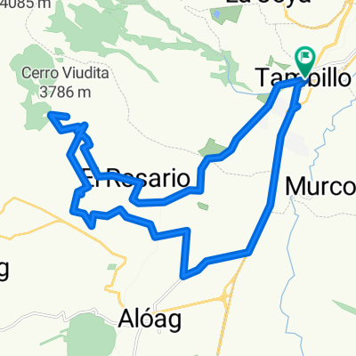
Mountain La Viudita located in the western mountain range next to Omoturco and Atacazo, can be accessed from the parishes of Tambillo and Alóag belonging to the Mejía Canton. It has an elevation of 3,735 meters above sea level.
- -:--
- Duration
- 33.1 km
- Distance
- 1,093 m
- Ascent
- 1,094 m
- Descent
- ---
- Avg. speed
- ---
- Max. altitude

Route highlights
Points of interest along the route
Point of interest after 0 km
Parque de Tambillo
Point of interest after 13.8 km
Antenas Viudita
Continue with Bikemap
Use, edit, or download this cycling route
You would like to ride MTB Antenas de la Viudita or customize it for your own trip? Here is what you can do with this Bikemap route:
Free features
- Save this route as favorite or in collections
- Copy & plan your own version of this route
- Sync your route with Garmin or Wahoo
Premium features
Free trial for 3 days, or one-time payment. More about Bikemap Premium.
- Navigate this route on iOS & Android
- Export a GPX / KML file of this route
- Create your custom printout (try it for free)
- Download this route for offline navigation
Discover more Premium features.
Get Bikemap PremiumFrom our community
Other popular routes starting in Machachi
 PISTA PEQUEÑA - COPA NECU 2da VALIDA
- Distance
- 0.7 km
- Ascent
- 29 m
- Descent
- 30 m
- Location
- Machachi, Pichincha, Ecuador
 MTB Antenas de la Viudita
- Distance
- 33.1 km
- Ascent
- 1,093 m
- Descent
- 1,094 m
- Location
- Machachi, Pichincha, Ecuador
 MTB Antenas de la Viudita
- Distance
- 33.1 km
- Ascent
- 1,093 m
- Descent
- 1,094 m
- Location
- Machachi, Pichincha, Ecuador
 CARRERA SIERRALOMA 2010 SEGUNDO DIA
- Distance
- 29 km
- Ascent
- 926 m
- Descent
- 926 m
- Location
- Machachi, Pichincha, Ecuador
 Tour Montaña Nestlé Papagayo 80k
- Distance
- 75.5 km
- Ascent
- 1,298 m
- Descent
- 1,298 m
- Location
- Machachi, Pichincha, Ecuador
 Travesía Cotopaxi - Mulaló
- Distance
- 53.8 km
- Ascent
- 490 m
- Descent
- 946 m
- Location
- Machachi, Pichincha, Ecuador
 CARRERA SIERRALOMA 2010 PRIMER DIA
- Distance
- 50.9 km
- Ascent
- 992 m
- Descent
- 992 m
- Location
- Machachi, Pichincha, Ecuador
 Tour Montaña Nestlé Papagayo 40k CLONED FROM ROUTE 1759217
- Distance
- 41.1 km
- Ascent
- 903 m
- Descent
- 903 m
- Location
- Machachi, Pichincha, Ecuador
Open it in the app