
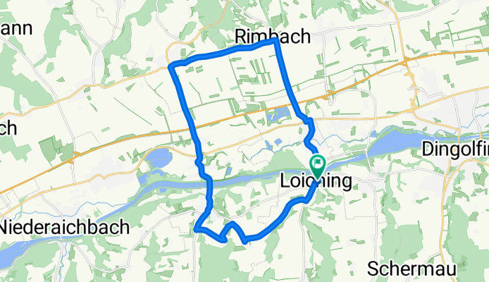
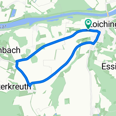
Rundfahrt Loiching
A cycling route starting in Loiching, Bavaria, Germany.
Overview
About this route
Ausgangspunkt in Loiching Feuerwehrhaus. Richtung Weigendorf aber noch vor dem Ortsende rechts nach Süßbach ansteigend bis Süßbach und zur Abzweigung nach Vorderkreuth. Abfallend zu Vorderkreuth. Nach Vorderkreuth wieder kurz ansteigend bevor es zu Hinterkreuth abfällt bis nach Niederviehbach. Auf ebener Hauptverbindungsstraße bis nach Weng zum Kreisverkehr. Den Kreisverkehr in der nächsten Ausfahrt Richtung Rimbach verlassen. In Rimbach dann rechts in Richtung Kronwieden und weiter bis nach Loiching zum Ausgangspunkt Feuerwehrhaus.
- -:--
- Duration
- 20.7 km
- Distance
- 122 m
- Ascent
- 125 m
- Descent
- ---
- Avg. speed
- 464 m
- Avg. speed
Route quality
Waytypes & surfaces along the route
Waytypes
Road
10.1 km
(48 %)
Quiet road
9 km
(43 %)
Surfaces
Paved
17.2 km
(83 %)
Asphalt
17.1 km
(83 %)
Paved (undefined)
0.1 km
(<1 %)
Undefined
3.5 km
(17 %)
Continue with Bikemap
Use, edit, or download this cycling route
You would like to ride Rundfahrt Loiching or customize it for your own trip? Here is what you can do with this Bikemap route:
Free features
- Save this route as favorite or in collections
- Copy & plan your own version of this route
- Sync your route with Garmin or Wahoo
Premium features
Free trial for 3 days, or one-time payment. More about Bikemap Premium.
- Navigate this route on iOS & Android
- Export a GPX / KML file of this route
- Create your custom printout (try it for free)
- Download this route for offline navigation
Discover more Premium features.
Get Bikemap PremiumFrom our community
Other popular routes starting in Loiching
 dgf - landau
- Distance
- 56.2 km
- Ascent
- 275 m
- Descent
- 275 m
- Location
- Loiching, Bavaria, Germany
 Altötting_2
- Distance
- 62.1 km
- Ascent
- 388 m
- Descent
- 395 m
- Location
- Loiching, Bavaria, Germany
 Praca
Praca- Distance
- 15.4 km
- Ascent
- 124 m
- Descent
- 165 m
- Location
- Loiching, Bavaria, Germany
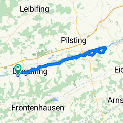
 Kronwieden über Weigendorf, Schermau, Dingolfing und zurück
- Distance
- 22.3 km
- Ascent
- 194 m
- Descent
- 196 m
- Location
- Loiching, Bavaria, Germany
 Dingolfing - Kirta-Radrennen
- Distance
- 6.8 km
- Ascent
- 154 m
- Descent
- 154 m
- Location
- Loiching, Bavaria, Germany
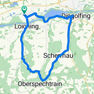
 Dingolfing- Oberwolkersdorf - Niederaichbach - Schlott
- Distance
- 42.3 km
- Ascent
- 464 m
- Descent
- 436 m
- Location
- Loiching, Bavaria, Germany
 Langsame Fahrt in Moosthenning
- Distance
- 7.6 km
- Ascent
- 24 m
- Descent
- 16 m
- Location
- Loiching, Bavaria, Germany
 Rundfahrt Loiching
- Distance
- 20.7 km
- Ascent
- 122 m
- Descent
- 125 m
- Location
- Loiching, Bavaria, Germany
Open it in the app