

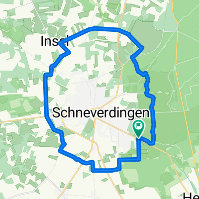
Schneverdingen-Wilseder Berg u. zurück
A cycling route starting in Schneverdingen, Lower Saxony, Germany.
Overview
About this route
Schneverdingen über Heidegarten und Niederhaverbeck zum Wilseder Berg. Mit Abstecher zum Totengrund.
- -:--
- Duration
- 36.5 km
- Distance
- 237 m
- Ascent
- 237 m
- Descent
- ---
- Avg. speed
- ---
- Avg. speed

Route quality
Waytypes & surfaces along the route
Waytypes
Track
20 km
(55 %)
Path
12.5 km
(34 %)
Surfaces
Paved
3.2 km
(9 %)
Unpaved
30.2 km
(83 %)
Gravel
16.7 km
(46 %)
Unpaved (undefined)
5.5 km
(15 %)
Continue with Bikemap
Use, edit, or download this cycling route
You would like to ride Schneverdingen-Wilseder Berg u. zurück or customize it for your own trip? Here is what you can do with this Bikemap route:
Free features
- Save this route as favorite or in collections
- Copy & plan your own version of this route
- Sync your route with Garmin or Wahoo
Premium features
Free trial for 3 days, or one-time payment. More about Bikemap Premium.
- Navigate this route on iOS & Android
- Export a GPX / KML file of this route
- Create your custom printout (try it for free)
- Download this route for offline navigation
Discover more Premium features.
Get Bikemap PremiumFrom our community
Other popular routes starting in Schneverdingen
 4_TourRundumSchneverdingen
- Distance
- 22.3 km
- Ascent
- 76 m
- Descent
- 76 m
- Location
- Schneverdingen, Lower Saxony, Germany
 Durch die Heide
- Distance
- 42.1 km
- Ascent
- 182 m
- Descent
- 180 m
- Location
- Schneverdingen, Lower Saxony, Germany
 Von Schneverdingen bis Buchholz in der Nordheide
- Distance
- 30.7 km
- Ascent
- 159 m
- Descent
- 172 m
- Location
- Schneverdingen, Lower Saxony, Germany
 Tag 2 Schneverdingen-Fintel
- Distance
- 35 km
- Ascent
- 81 m
- Descent
- 84 m
- Location
- Schneverdingen, Lower Saxony, Germany
 Melkhus Fintel
- Distance
- 28 km
- Ascent
- 58 m
- Descent
- 55 m
- Location
- Schneverdingen, Lower Saxony, Germany
 Heber 14 km
- Distance
- 14 km
- Ascent
- 44 m
- Descent
- 37 m
- Location
- Schneverdingen, Lower Saxony, Germany
 heide
heide- Distance
- 47.5 km
- Ascent
- 192 m
- Descent
- 191 m
- Location
- Schneverdingen, Lower Saxony, Germany
 02-Schneverdingen-Hitzacker-102km
- Distance
- 101.3 km
- Ascent
- 608 m
- Descent
- 679 m
- Location
- Schneverdingen, Lower Saxony, Germany
Open it in the app