

30.08.2015 15:25
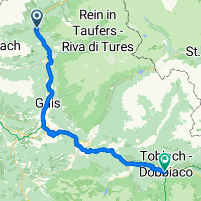
A cycling route starting in Sand in Taufers, Trentino-Alto Adige, Italy.
Overview
About this route
03.09.15 13:37
- -:--
- Duration
- 23.7 km
- Distance
- 750 m
- Ascent
- 750 m
- Descent
- ---
- Avg. speed
- ---
- Avg. speed
Route quality
Waytypes & surfaces along the route
Waytypes
Track
15.7 km
(66 %)
Busy road
4.2 km
(18 %)
Surfaces
Paved
7.8 km
(33 %)
Unpaved
15 km
(63 %)
Loose gravel
12 km
(51 %)
Asphalt
6.3 km
(27 %)
Continue with Bikemap
Use, edit, or download this cycling route
You would like to ride 30.08.2015 15:25 or customize it for your own trip? Here is what you can do with this Bikemap route:
Free features
- Save this route as favorite or in collections
- Copy & plan your own version of this route
- Sync your route with Garmin or Wahoo
Premium features
Free trial for 3 days, or one-time payment. More about Bikemap Premium.
- Navigate this route on iOS & Android
- Export a GPX / KML file of this route
- Create your custom printout (try it for free)
- Download this route for offline navigation
Discover more Premium features.
Get Bikemap PremiumFrom our community
Other popular routes starting in Sand in Taufers
 Blossberg
- Distance
- 19.4 km
- Ascent
- 1,756 m
- Descent
- 73 m
- Location
- Sand in Taufers, Trentino-Alto Adige, Italy
 Sand - Prettau - Kehreralm
- Distance
- 30.7 km
- Ascent
- 949 m
- Descent
- 0 m
- Location
- Sand in Taufers, Trentino-Alto Adige, Italy
 Malga Gruber
- Distance
- 21.5 km
- Ascent
- 873 m
- Descent
- 868 m
- Location
- Sand in Taufers, Trentino-Alto Adige, Italy
 Via Unterpojen, Campo Tures to Bahnhofsplatz, Lienz
- Distance
- 101.7 km
- Ascent
- 1,516 m
- Descent
- 2,028 m
- Location
- Sand in Taufers, Trentino-Alto Adige, Italy
 a-high-mountain-route-in-the-natural-park-rieserfern-ahr - proposed
- Distance
- 93.1 km
- Ascent
- 1,872 m
- Descent
- 1,874 m
- Location
- Sand in Taufers, Trentino-Alto Adige, Italy
 Klammljoch
- Distance
- 92.4 km
- Ascent
- 2,843 m
- Descent
- 2,842 m
- Location
- Sand in Taufers, Trentino-Alto Adige, Italy
 Un passo dal Cielo-Agosto 2021-Valle Aurina, Dobbiaco
- Distance
- 51.4 km
- Ascent
- 474 m
- Descent
- 224 m
- Location
- Sand in Taufers, Trentino-Alto Adige, Italy
 Anello Castello Tures - cascate Riva
- Distance
- 9 km
- Ascent
- 376 m
- Descent
- 375 m
- Location
- Sand in Taufers, Trentino-Alto Adige, Italy
Open it in the app