

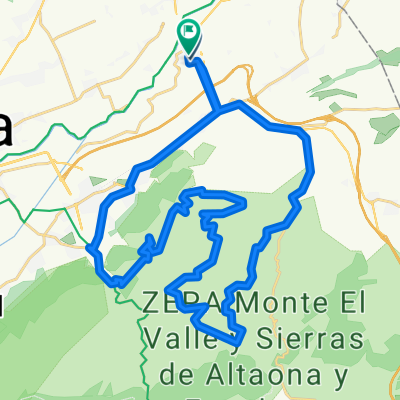
GUARDAMAR DEL SEGURA
A cycling route starting in Beniel, Murcia, Spain.
Overview
About this route
- -:--
- Duration
- 84.8 km
- Distance
- 81 m
- Ascent
- 84 m
- Descent
- ---
- Avg. speed
- ---
- Avg. speed

Route quality
Waytypes & surfaces along the route
Waytypes
Busy road
56.9 km
(67 %)
Road
12.3 km
(15 %)
Surfaces
Paved
8.9 km
(11 %)
Unpaved
0.6 km
(<1 %)
Asphalt
8.9 km
(10 %)
Gravel
0.6 km
(<1 %)
Continue with Bikemap
Use, edit, or download this cycling route
You would like to ride GUARDAMAR DEL SEGURA or customize it for your own trip? Here is what you can do with this Bikemap route:
Free features
- Save this route as favorite or in collections
- Copy & plan your own version of this route
- Sync your route with Garmin or Wahoo
Premium features
Free trial for 3 days, or one-time payment. More about Bikemap Premium.
- Navigate this route on iOS & Android
- Export a GPX / KML file of this route
- Create your custom printout (try it for free)
- Download this route for offline navigation
Discover more Premium features.
Get Bikemap PremiumFrom our community
Other popular routes starting in Beniel
 ESTACION DE BLANCA
- Distance
- 97.6 km
- Ascent
- 497 m
- Descent
- 496 m
- Location
- Beniel, Murcia, Spain
 los tres perdios
- Distance
- 45.7 km
- Ascent
- 626 m
- Descent
- 629 m
- Location
- Beniel, Murcia, Spain
 GENOVINOS-GARRUCHAL-CRESTA DEL GALLO-CRESTA-GARRUCHAL-GENOVINOS-ANTENAS DE HURCHILLO
- Distance
- 158.4 km
- Ascent
- 1,217 m
- Descent
- 1,218 m
- Location
- Beniel, Murcia, Spain
 alquerias, abanilla, macisvenda, el canton, cañada de la leña, fortuna, abanilla, alquerias
- Distance
- 92 km
- Ascent
- 1,183 m
- Descent
- 1,185 m
- Location
- Beniel, Murcia, Spain
 PUERTO FRIO POR DETRAS
- Distance
- 102.5 km
- Ascent
- 916 m
- Descent
- 917 m
- Location
- Beniel, Murcia, Spain
 LA PINILLA
- Distance
- 140.1 km
- Ascent
- 600 m
- Descent
- 600 m
- Location
- Beniel, Murcia, Spain
 GUARDAMAR, TORREVIEJA, EL PILAR
- Distance
- 113 km
- Ascent
- 446 m
- Descent
- 445 m
- Location
- Beniel, Murcia, Spain
 TRES EMBALSES
- Distance
- 110.1 km
- Ascent
- 673 m
- Descent
- 677 m
- Location
- Beniel, Murcia, Spain
Open it in the app