

Lukas-Route.gpx
A cycling route starting in Kuppenheim, Baden-Württemberg, Germany.
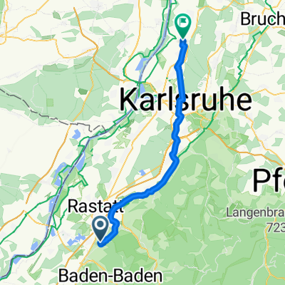
Overview
About this route
TEASI track
- -:--
- Duration
- 18.6 km
- Distance
- 449 m
- Ascent
- 449 m
- Descent
- ---
- Avg. speed
- ---
- Avg. speed
Continue with Bikemap
Use, edit, or download this cycling route
You would like to ride Lukas-Route.gpx or customize it for your own trip? Here is what you can do with this Bikemap route:
Free features
- Save this route as favorite or in collections
- Copy & plan your own version of this route
- Sync your route with Garmin or Wahoo
Premium features
Free trial for 3 days, or one-time payment. More about Bikemap Premium.
- Navigate this route on iOS & Android
- Export a GPX / KML file of this route
- Create your custom printout (try it for free)
- Download this route for offline navigation
Discover more Premium features.
Get Bikemap PremiumFrom our community
Other popular routes starting in Kuppenheim
 Baden-Baden Schloss Gaggenau und zurück
- Distance
- 29.5 km
- Ascent
- 336 m
- Descent
- 335 m
- Location
- Kuppenheim, Baden-Württemberg, Germany
 schwarzwald
- Distance
- 111.3 km
- Ascent
- 2,212 m
- Descent
- 2,191 m
- Location
- Kuppenheim, Baden-Württemberg, Germany
 Schnelle Runde
- Distance
- 25.2 km
- Ascent
- 142 m
- Descent
- 141 m
- Location
- Kuppenheim, Baden-Württemberg, Germany
 3 Schlösser - Balg Variante
- Distance
- 22.7 km
- Ascent
- 350 m
- Descent
- 351 m
- Location
- Kuppenheim, Baden-Württemberg, Germany
 Leopoldshafen
- Distance
- 43.9 km
- Ascent
- 37 m
- Descent
- 55 m
- Location
- Kuppenheim, Baden-Württemberg, Germany
 Flaiky's Favorit
- Distance
- 54.3 km
- Ascent
- 1,703 m
- Descent
- 1,636 m
- Location
- Kuppenheim, Baden-Württemberg, Germany
 Geroldsauermühle über Burg Windeck
- Distance
- 52.1 km
- Ascent
- 665 m
- Descent
- 665 m
- Location
- Kuppenheim, Baden-Württemberg, Germany
 Durch den Hardwald
- Distance
- 50.9 km
- Ascent
- 122 m
- Descent
- 122 m
- Location
- Kuppenheim, Baden-Württemberg, Germany
Open it in the app