

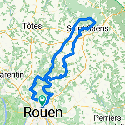
Haute Normandie: Rouen-Dieppe
A cycling route starting in Mont-Saint-Aignan, Normandy, France.
Overview
About this route
I had a hard time finding my way out of Rouen but finally enjoyed the much to hilly route and forestside. Its a good road, and once you got out of Rouen its easy to get to dieppe by following the signs.
- -:--
- Duration
- 70.7 km
- Distance
- 417 m
- Ascent
- 371 m
- Descent
- ---
- Avg. speed
- 179 m
- Avg. speed
Route quality
Waytypes & surfaces along the route
Waytypes
Busy road
40.8 km
(58 %)
Quiet road
8.5 km
(12 %)
Surfaces
Paved
39.3 km
(56 %)
Unpaved
1.5 km
(2 %)
Asphalt
38.2 km
(54 %)
Concrete
1.2 km
(2 %)
Continue with Bikemap
Use, edit, or download this cycling route
You would like to ride Haute Normandie: Rouen-Dieppe or customize it for your own trip? Here is what you can do with this Bikemap route:
Free features
- Save this route as favorite or in collections
- Copy & plan your own version of this route
- Sync your route with Garmin or Wahoo
Premium features
Free trial for 3 days, or one-time payment. More about Bikemap Premium.
- Navigate this route on iOS & Android
- Export a GPX / KML file of this route
- Create your custom printout (try it for free)
- Download this route for offline navigation
Discover more Premium features.
Get Bikemap PremiumFrom our community
Other popular routes starting in Mont-Saint-Aignan
 lyon foret
- Distance
- 82.7 km
- Ascent
- 599 m
- Descent
- 601 m
- Location
- Mont-Saint-Aignan, Normandy, France
 Saint Désir - Mont Saint Aignan
- Distance
- 93.3 km
- Ascent
- 558 m
- Descent
- 474 m
- Location
- Mont-Saint-Aignan, Normandy, France
 De Chemin de la Bretèque 1227, Bois-Guillaume à Chemin de la Bretèque 1196, Houppeville
- Distance
- 11.8 km
- Ascent
- 235 m
- Descent
- 238 m
- Location
- Mont-Saint-Aignan, Normandy, France
 GRAVEL forêts Bretèque Eawy
- Distance
- 97.1 km
- Ascent
- 1,226 m
- Descent
- 1,228 m
- Location
- Mont-Saint-Aignan, Normandy, France
 Rouen Fécamp 135kms via la véloroute du lin
- Distance
- 132.9 km
- Ascent
- 1,126 m
- Descent
- 1,216 m
- Location
- Mont-Saint-Aignan, Normandy, France
 boucle entrainement 200917
- Distance
- 30.8 km
- Ascent
- 417 m
- Descent
- 417 m
- Location
- Mont-Saint-Aignan, Normandy, France
 MSA - Cany-Barville
- Distance
- 57.8 km
- Ascent
- 361 m
- Descent
- 439 m
- Location
- Mont-Saint-Aignan, Normandy, France
 sortie avec allan sylvain
- Distance
- 12.9 km
- Ascent
- 212 m
- Descent
- 200 m
- Location
- Mont-Saint-Aignan, Normandy, France
Open it in the app