

20150920_135825.gpx
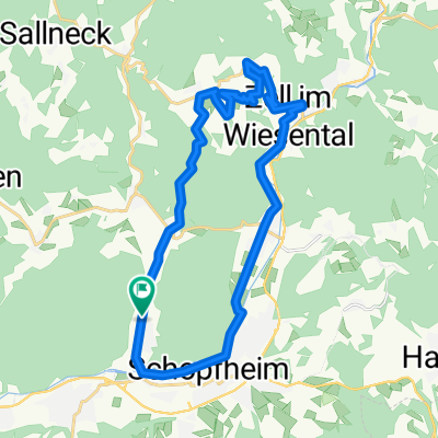
A cycling route starting in Schopfheim, Baden-Württemberg, Germany.
Overview
About this route
TEASI track
- -:--
- Duration
- 40.3 km
- Distance
- 409 m
- Ascent
- 407 m
- Descent
- ---
- Avg. speed
- ---
- Avg. speed
Route quality
Waytypes & surfaces along the route
Waytypes
Track
18.3 km
(46 %)
Quiet road
8.2 km
(20 %)
Surfaces
Paved
20.4 km
(51 %)
Unpaved
16.9 km
(42 %)
Asphalt
17.4 km
(43 %)
Gravel
14.3 km
(35 %)
Continue with Bikemap
Use, edit, or download this cycling route
You would like to ride 20150920_135825.gpx or customize it for your own trip? Here is what you can do with this Bikemap route:
Free features
- Save this route as favorite or in collections
- Copy & plan your own version of this route
- Sync your route with Garmin or Wahoo
Premium features
Free trial for 3 days, or one-time payment. More about Bikemap Premium.
- Navigate this route on iOS & Android
- Export a GPX / KML file of this route
- Create your custom printout (try it for free)
- Download this route for offline navigation
Discover more Premium features.
Get Bikemap PremiumFrom our community
Other popular routes starting in Schopfheim
 Schopfheim - Schlächtenhaus - Hauingen - Schopfheim
- Distance
- 36.9 km
- Ascent
- 490 m
- Descent
- 488 m
- Location
- Schopfheim, Baden-Württemberg, Germany
 Blünimattstraße 9A, Schopfheim nach Blünimattstraße 9A, Schopfheim
- Distance
- 24.9 km
- Ascent
- 554 m
- Descent
- 556 m
- Location
- Schopfheim, Baden-Württemberg, Germany
 Hohe Flum
- Distance
- 18.2 km
- Ascent
- 265 m
- Descent
- 263 m
- Location
- Schopfheim, Baden-Württemberg, Germany
 schopfheim Schaui Freiburg
- Distance
- 56.2 km
- Ascent
- 1,400 m
- Descent
- 1,062 m
- Location
- Schopfheim, Baden-Württemberg, Germany
 Die Höhlentour
- Distance
- 21.6 km
- Ascent
- 384 m
- Descent
- 384 m
- Location
- Schopfheim, Baden-Württemberg, Germany
 Erdmannshöhle und Eichener See
- Distance
- 27.1 km
- Ascent
- 454 m
- Descent
- 454 m
- Location
- Schopfheim, Baden-Württemberg, Germany
 20200726 Schopfheim
- Distance
- 68.6 km
- Ascent
- 401 m
- Descent
- 401 m
- Location
- Schopfheim, Baden-Württemberg, Germany
 Samtagroute
- Distance
- 38.8 km
- Ascent
- 740 m
- Descent
- 739 m
- Location
- Schopfheim, Baden-Württemberg, Germany
Open it in the app